Fichier:Map of Seattle, divided by districts.png
Taille de cet aperçu : 352 × 599 pixels. Autres résolutions : 141 × 240 pixels | 586 × 998 pixels.
Fichier d’origine (586 × 998 pixels, taille du fichier : 284 kio, type MIME : image/png)
Ce fichier et sa description proviennent de Wikimedia Commons.
Le fait que le bandeau de droits d’auteur soit correct ou non est remis en cause sur ce fichier. Dans certains cas, cela peut être parce que la source indiquée ou d’autres informations ne sont pas suffisantes pour prouver que le bandeau sélectionné est correct. Reason: Author is said to be "US Federal Government", however the source actually says "All content is provided by City Neighborhood Council." (Of Seattle, not part of the federal government.) [1]. PD-USGov would thus be invalid. Copyright claims are made at the source.
Avec l’outil CheckUsage, vous pouvez vérifier l’utilisation de ce fichier sur les autres projets Wikimedia
Ne pas utiliser ce bandeau pour les fichiers provenant de tiers sans preuve d’une autorisation de le publier sous une licence compatible, utiliser {{subst:Npd}} pour ces cas. |
Description
| Description |
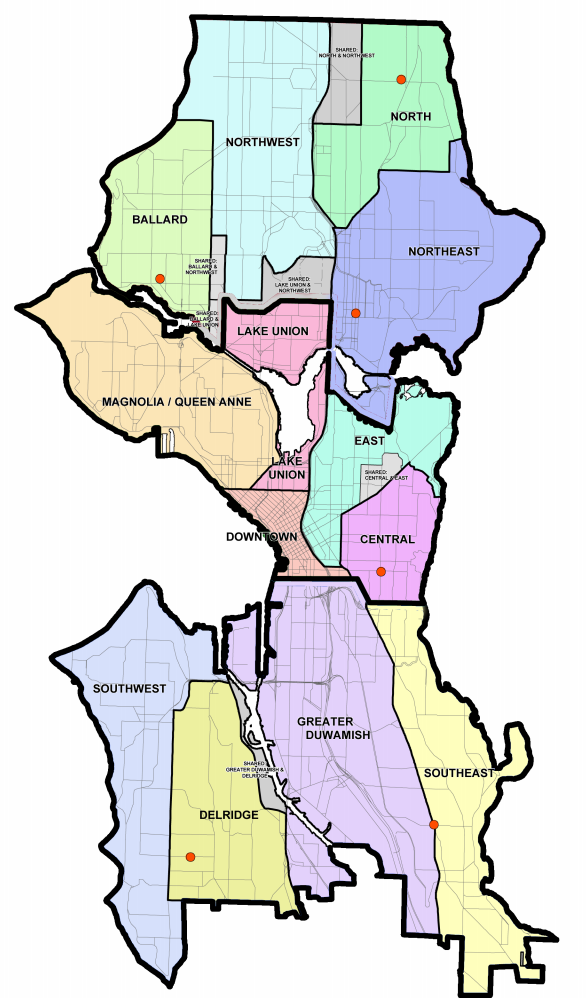
English: Map of Seattle, WA with divisions showing where different districts are. |
| Source | http://www.seattle.gov/neighborhoodcouncil/documents/CURRENTdistrictandNSCmap.pdf |
| Auteur | US Federal Government |
Conditions d’utilisation
Ce média est dans le domaine public des États-Unis d’Amérique car son auteur est l’administration américaine comme précisé dans le code fédéral au Titre 17, Chapitre 1, Section 105. Pour en savoir plus : droit d’auteur.
Attention : Ceci ne concerne que le travail du Gouvernement Fédéral et pas celui des États, ou d’une autre subdivision géographique ou politique du pays.
|
 | |
| Ce fichier a été identifié comme étant exempt de restrictions connues liées au droit d’auteur, y compris tous les droits connexes et voisins. | ||
Historique du fichier
Cliquer sur une date et heure pour voir le fichier tel qu'il était à ce moment-là.
| Date et heure | Vignette | Dimensions | Utilisateur | Commentaire | |
|---|---|---|---|---|---|
| actuel | 28 février 2013 à 05:35 | | 586 × 998 (284 kio) | Sainid | {{subst:Upload marker added by en.wp UW}} {{Information |Description = {{en|Map of Seattle, WA with divisions showing where different districts are.}} |Source = http://www.seattle.gov/neighborhoodcouncil/documents/CURRENTdistrictandNSCmap.pdf |Author =... |
Utilisation du fichier
La page suivante utilise ce fichier :
Usage global du fichier
Les autres wikis suivants utilisent ce fichier :
- Utilisation sur nl.wikipedia.org