Fichier:Map of Thera before the Minoan eruption.png

Taille de cet aperçu : 520 × 599 pixels. Autres résolutions : 208 × 240 pixels | 417 × 480 pixels | 667 × 768 pixels | 1 171 × 1 349 pixels.
Fichier d’origine (1 171 × 1 349 pixels, taille du fichier : 179 kio, type MIME : image/png)
Ce fichier et sa description proviennent de Wikimedia Commons.
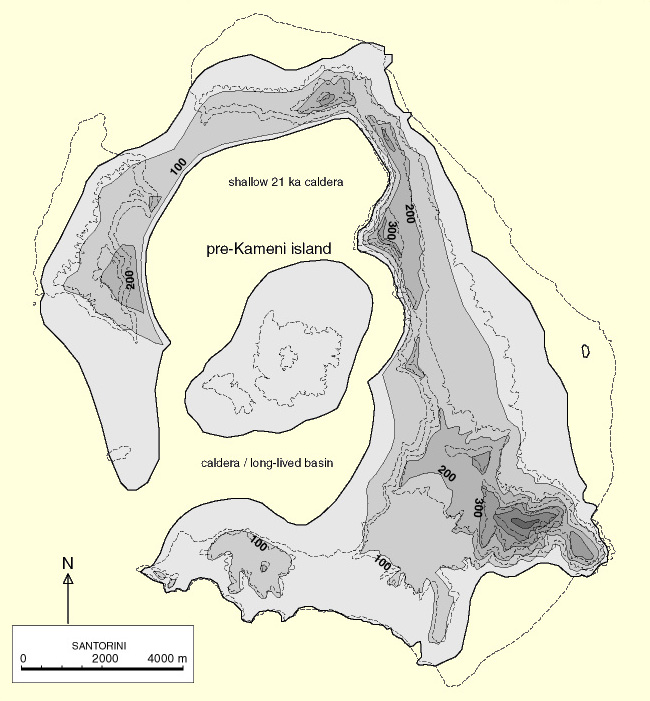
| Description |
Deutsch: Karte der Insel Thera vor der Minoischen Eruption
English: Map of Thera island before the Minoan eruption |
| Date | see file history |
| Source |
Travail personnel, using
|
| Auteur | Maximilian Dörrbecker (Chumwa) |
| Autorisation (Réutilisation de ce fichier) |
Moi, en tant que détenteur des droits d’auteur sur cette œuvre, je la publie sous la licence suivante : Ce fichier est disponible selon les termes de la licence Creative Commons Attribution – Partage dans les Mêmes Conditions 2.5 Générique
Sie dürfen das Bild zu den folgenden Bedingungen nutzen:
|
| Autres versions | Map of Thera before the Minoan eruption (Druitt, Francaviglia).png |
.png)
Historique du fichier
Cliquer sur une date et heure pour voir le fichier tel qu'il était à ce moment-là.
| Date et heure | Vignette | Dimensions | Utilisateur | Commentaire | |
|---|---|---|---|---|---|
| actuel | 20 février 2016 à 09:18 | | 1 171 × 1 349 (179 kio) | Chumwa | |
| 18 février 2016 à 23:24 |  | 1 171 × 1 349 (171 kio) | Chumwa | ||
| 15 février 2016 à 23:24 |  | 1 171 × 1 349 (172 kio) | Chumwa | {{Information |Description= {{de|Karte der Insel Thera vor der Minoischen Eruption}} {{en|Map of Thera island before the Minoan eruption}} |Source={{Own}}, using * this file by {{U|FinnWikiNo}} * [[:File:Santorin.png|this f... |
Utilisation du fichier
La page suivante utilise ce fichier :
Usage global du fichier
Les autres wikis suivants utilisent ce fichier :
- Utilisation sur de.wikipedia.org
- Utilisation sur pt.wikipedia.org