Fichier:Map of the States Traversed by the St. Louis, Iron Mountain and Southern Railway 1882 UTA.jpg

Taille de cet aperçu : 800 × 468 pixels. Autres résolutions : 320 × 187 pixels | 640 × 375 pixels | 1 024 × 599 pixels | 1 280 × 749 pixels | 2 560 × 1 499 pixels | 4 438 × 2 598 pixels.
Fichier d’origine (4 438 × 2 598 pixels, taille du fichier : 3,04 Mio, type MIME : image/jpeg)
Ce fichier et sa description proviennent de Wikimedia Commons.
Description
| Titre |
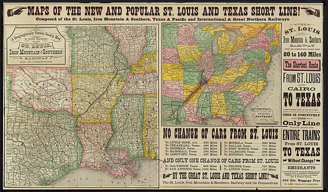
English: A Geographically Correct County Map of the States Traversed by the St. Louis, Iron Mountain and Southern Railway and its Connections |
||||||||||||||||||||||||||
| Date | |||||||||||||||||||||||||||
| Source | UTA Libraries Cartographic Connections: carte / texte | ||||||||||||||||||||||||||
| Créé par |
Auteur inconnu |
||||||||||||||||||||||||||
| Attribution de l’acquisition |
English: The University of Texas at Arlington Libraries Special Collections |
||||||||||||||||||||||||||
| Données géotemporelles | |||||||||||||||||||||||||||
| Lieu | États-Unis | ||||||||||||||||||||||||||
| Géoréférencement | Si c'est inapproprié, définissez warp_status = skip pour masquer. | ||||||||||||||||||||||||||
| Données bibliographiques | |||||||||||||||||||||||||||
| Lieu de publication | Saint-Louis | ||||||||||||||||||||||||||
| Éditeur de publication |
Woodward, Tiernan & Hale |
||||||||||||||||||||||||||
| Données d'archives | |||||||||||||||||||||||||||
| Collection |
|
||||||||||||||||||||||||||
Conditions d’utilisation

|
This file was provided to Wikimedia Commons by the University of Texas at Arlington Libraries as part of a cooperation project. The University of Texas at Arlington Libraries is part of the University of Texas at Arlington, a public research university located in Arlington, Texas.
|
Cette œuvre a été publiée avant le 1er janvier 1929. Son auteur n'étant pas connu, cette œuvre est anonyme. Elle est donc dans le domaine public aux États-Unis, ainsi que dans les pays où la durée du droit d'auteur pour les œuvres anonymes est inférieure à 95 ans après la date de première publication.
|
Historique du fichier
Cliquer sur une date et heure pour voir le fichier tel qu'il était à ce moment-là.
| Date et heure | Vignette | Dimensions | Utilisateur | Commentaire | |
|---|---|---|---|---|---|
| actuel | 15 avril 2022 à 22:15 | | 4 438 × 2 598 (3,04 Mio) | Michael Barera | == {{int:filedesc}} == {{Map |title = {{en|'''''A Geographically Correct County Map of the States Traversed by the St. Louis, Iron Mountain and Southern Railway and its Connections'''''}} |description = |legend = |author = {{Unknown|author}} |date = 1882 |source = UTA Libraries ''Cartographic Connections'': [https://libguides.uta.edu/ld.php?content_id=931894 {{I18n/map}}] / [https://libguides.uta.edu/ccon {{I18n/text}}] |... |
Utilisation du fichier
La page suivante utilise ce fichier :