Fichier:Map showing flight path of Qantas Flight 32 on 4 November 2010.png
Pas de plus haute résolution disponible.
Map_showing_flight_path_of_Qantas_Flight_32_on_4_November_2010.png (252 × 271 pixels, taille du fichier : 39 kio, type MIME : image/png)
Ce fichier et sa description proviennent de Wikimedia Commons.
Description
| Description |
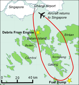
English: A map showing the flight path of Qantas Flight 32 on 4 novembre 2010 when it suffered a turbine engine failure and made an emergency landing at Singapore Changi Airport. The failure was the first of its kind for the four-engined Airbus A380. |
| Date | 5 novembre 2010 (date de téléversement originale). |
| Source | Travail personnel; partly derived from File:Batam.png. |
| Auteur | Advanstra. |
Conditions d’utilisation
Ce fichier est disponible selon les termes de la licence Creative Commons Attribution – Partage dans les Mêmes Conditions 3.0 (non transposée).
- Vous êtes libre :
- de partager – de copier, distribuer et transmettre cette œuvre
- d’adapter – de modifier cette œuvre
- Sous les conditions suivantes :
- paternité – Vous devez donner les informations appropriées concernant l'auteur, fournir un lien vers la licence et indiquer si des modifications ont été faites. Vous pouvez faire cela par tout moyen raisonnable, mais en aucune façon suggérant que l’auteur vous soutient ou approuve l’utilisation que vous en faites.
- partage à l’identique – Si vous modifiez, transformez, ou vous basez sur cette œuvre, vous devez distribuer votre contribution sous la même licence ou une licence compatible avec celle de l’original.
Historique du fichier
Cliquer sur une date et heure pour voir le fichier tel qu'il était à ce moment-là.
| Date et heure | Vignette | Dimensions | Utilisateur | Commentaire | |
|---|---|---|---|---|---|
| actuel | 11 août 2019 à 00:55 | | 252 × 271 (39 kio) | High source | km map |
| 5 novembre 2010 à 04:56 |  | 252 × 271 (42 kio) | Advanstra | Flight path of QF32 and location of events Category:Singapore Changi Airport Category:Aviation accidents in Indonesia Category:Qantas |
Utilisation du fichier
La page suivante utilise ce fichier :
Usage global du fichier
Les autres wikis suivants utilisent ce fichier :
- Utilisation sur en.wikipedia.org
- Utilisation sur he.wikipedia.org
- Utilisation sur pt.wikipedia.org
- Utilisation sur ru.wikipedia.org