Fichier:Mars topography (MOLA dataset) HiRes.jpg

Taille de cet aperçu : 800 × 457 pixels. Autres résolutions : 320 × 183 pixels | 640 × 366 pixels | 1 024 × 585 pixels | 1 280 × 732 pixels | 2 560 × 1 463 pixels | 12 140 × 6 940 pixels.
Fichier d’origine (12 140 × 6 940 pixels, taille du fichier : 17,2 Mio, type MIME : image/jpeg)
Ce fichier et sa description proviennent de Wikimedia Commons.
Description
| Description |
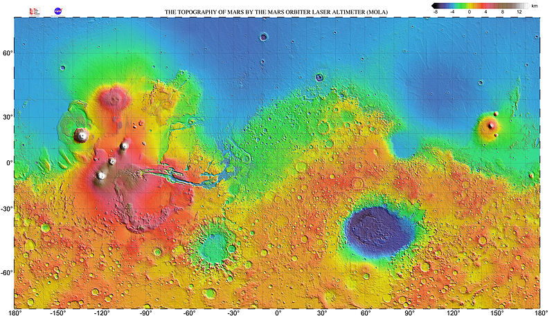
English: Very high resolution topographic shaded relief map of Mars. The map has a resolution 0.125° (300 dots per inch) and is shown as a mercator projection to latitude 70° north and south. The original NASA image has been modified by increasing the font size of the map grid and elevation key labels. |
| Date | |
| Source | http://mola.gsfc.nasa.gov/images.html |
| Auteur | NASA |
| Autres versions |

|
_with_poles_HiRes.jpg)
_HiRes.jpg?uselang=fr)
_HiRes.jpg&flash=no)
Conditions d’utilisation
| Ce fichier provient de la NASA. Sauf exception, les documents créés par la NASA ne sont pas soumis à copyright. Pour plus d'informations, voir la politique de copyright de la NASA. | ||
 |
Attention :
|
| Annotations | Cette image est annotée : Voir les annotations sur Wikimedia Commons |
_HiRes.jpg)
Historique du fichier
Cliquer sur une date et heure pour voir le fichier tel qu'il était à ce moment-là.
| Date et heure | Vignette | Dimensions | Utilisateur | Commentaire | |
|---|---|---|---|---|---|
| actuel | 23 mai 2014 à 09:35 | | 12 140 × 6 940 (17,2 Mio) | WolfmanSF | further increase font size for map grid & color key labels |
| 19 mai 2014 à 09:37 |  | 12 032 × 6 912 (17,88 Mio) | WolfmanSF | Increase font size on map grid labels | |
| 11 mars 2009 à 05:44 |  | 12 032 × 6 912 (17,6 Mio) | Masur | {{Information |Description={{en|1=Very high resolution topographic shaded relief map of Mars. The map has a resolution 0.125° (300 dots per inch) and is shown as a mercator projection to latitude 70° north and south.}} |Source=http://mola.gsfc.nasa.gov/ |
Utilisation du fichier
Les 2 pages suivantes utilisent ce fichier :
Usage global du fichier
Les autres wikis suivants utilisent ce fichier :
- Utilisation sur ja.wikibooks.org
- Utilisation sur ru.wikipedia.org
- Utilisation sur uk.wikipedia.org
- Utilisation sur zh.wikipedia.org
_HiRes.jpg)