Fichier:Memorial to Tom Pryce, additional information - geograph.org.uk - 1614415.jpg
Pas de plus haute résolution disponible.
Memorial_to_Tom_Pryce,_additional_information_-_geograph.org.uk_-_1614415.jpg (536 × 317 pixels, taille du fichier : 192 kio, type MIME : image/jpeg)
Ce fichier et sa description proviennent de Wikimedia Commons.
Description
| Description |
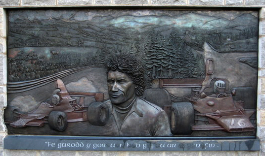
English: Memorial to Tom Pryce, additional information Tom was born at Rosset but moved to Ruthin with his parents and worked as an engineer for North Wales Agricultural Engineers in St Asaph (hence the tractor in the mural). Tom was driving for the F1 Shadow Team and making a name for himself as fast and skilled driver with a reputation for being unbeatable in the wet! The memorial was organised through a Trust chaired by local fellow Welshman and prominent motorsport chief David Richards of Prodrive, Benetton & BAR fame. The memorial is a fitting tribute to the only Welsh racing driver ever to win an F1 race and unveiled on what would have been his sixtieth birthday. |
| Date | |
| Source | From geograph.org.uk |
| Auteur | David M Jones |
| Attribution (imposé par la licence) | David M Jones / Memorial to Tom Pryce, additional information / |
| Lieu de la prise de vue | | Voir cet endroit et d’autres images sur : OpenStreetMap |
|---|
_heading:67.00&language=fr)
| Position de l'objet | | Voir cet endroit et d’autres images sur : OpenStreetMap |
|---|
_heading:67.00&language=fr)
Conditions d’utilisation

|
Cette image provient de la collection du projet Geograph British Isles. Pour obtenir les coordonnées du photographe, veuillez consulter cette page de description de l'image sur le site du projet. Les droits d'auteurs sur cette image sont détenus par David M Jones ; l'image est placée sous une licence Creative Commons avec mention de paternité et partage à l'identique (CC-By-SA) en version 2.0.
|
Ce fichier est disponible selon les termes de la licence Creative Commons Attribution – Partage dans les Mêmes Conditions 2.0 Générique
Attribution: David M Jones
- Vous êtes libre :
- de partager – de copier, distribuer et transmettre cette œuvre
- d’adapter – de modifier cette œuvre
- Sous les conditions suivantes :
- paternité – Vous devez donner les informations appropriées concernant l'auteur, fournir un lien vers la licence et indiquer si des modifications ont été faites. Vous pouvez faire cela par tout moyen raisonnable, mais en aucune façon suggérant que l’auteur vous soutient ou approuve l’utilisation que vous en faites.
- partage à l’identique – Si vous modifiez, transformez, ou vous basez sur cette œuvre, vous devez distribuer votre contribution sous la même licence ou une licence compatible avec celle de l’original.
Historique du fichier
Cliquer sur une date et heure pour voir le fichier tel qu'il était à ce moment-là.
| Date et heure | Vignette | Dimensions | Utilisateur | Commentaire | |
|---|---|---|---|---|---|
| actuel | 6 juin 2014 à 00:29 | | 536 × 317 (192 kio) | Guinnog | crop, levels |
| 4 mars 2011 à 12:14 |  | 640 × 480 (82 kio) | GeographBot | == {{int:filedesc}} == {{Information |description={{en|1=Memorial to Tom Pryce, additional information Tom was born at Rosset but moved to Ruthin with his parents and worked as an engineer for North Wales Agricultural Engineers in St Asaph (hence the trac |
Utilisation du fichier
La page suivante utilise ce fichier :
Usage global du fichier
Les autres wikis suivants utilisent ce fichier :
- Utilisation sur cs.wikipedia.org
- Utilisation sur de.wikipedia.org
- Utilisation sur en.wikipedia.org
- Utilisation sur hu.wikipedia.org
- Utilisation sur it.wikipedia.org
- Utilisation sur ja.wikipedia.org
- Utilisation sur simple.wikipedia.org
- Utilisation sur www.wikidata.org