Fichier:Military administration Belgium Northern France.png
Taille de cet aperçu : 800 × 358 pixels. Autres résolutions : 320 × 143 pixels | 1 000 × 448 pixels.
Fichier d’origine (1 000 × 448 pixels, taille du fichier : 142 kio, type MIME : image/png)
Ce fichier et sa description proviennent de Wikimedia Commons.
Description
| Description |
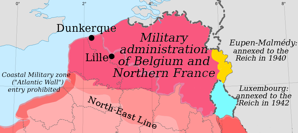
English: Map of the German military administration of Belgium and Northern France. |
| Date | |
| Source | self-made map, derived from File:France_map_Lambert-93_with_regions_and_departments-occupation.svg |
| Auteur | Original creators were Eric Gaba (Sting) for the original blank map and Rama for the zones. |
Conditions d’utilisation
| Moi, propriétaire des droits d’auteur sur cette œuvre, la place dans le domaine public. Ceci s'applique dans le monde entier. Dans certains pays, ceci peut ne pas être possible ; dans ce cas : J’accorde à toute personne le droit d’utiliser cette œuvre dans n’importe quel but, sans aucune condition, sauf celles requises par la loi. |
Historique du fichier
Cliquer sur une date et heure pour voir le fichier tel qu'il était à ce moment-là.
| Date et heure | Vignette | Dimensions | Utilisateur | Commentaire | |
|---|---|---|---|---|---|
| actuel | 25 mai 2014 à 13:08 | | 1 000 × 448 (142 kio) | Victor falk~commonswiki | based on File:France map Lambert-93 with regions and departments-occupation Belgium.png |
| 30 octobre 2010 à 00:36 |  | 290 × 139 (26 kio) | Morgan Hauser | {{Information |Description={{en|1=Map of the German military administration of Belgium and Northern France.}} |Source=self-made map, derived from File:France_map_Lambert-93_with_regions_and_departments-occupation.svg |Author=Original creators were Er |
Utilisation du fichier
La page suivante utilise ce fichier :
Usage global du fichier
Les autres wikis suivants utilisent ce fichier :
- Utilisation sur bs.wikipedia.org
- Utilisation sur de.wikipedia.org
- Utilisation sur nl.wikipedia.org
- Utilisation sur no.wikipedia.org
- Utilisation sur sh.wikipedia.org
- Utilisation sur sr.wikipedia.org