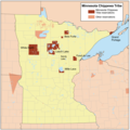
Fichier:Mnchippewamap.png

Taille de cet aperçu : 600 × 600 pixels. Autres résolutions : 240 × 240 pixels | 480 × 480 pixels.
Fichier d’origine (800 × 800 pixels, taille du fichier : 315 kio, type MIME : image/png)
Historique du fichier
Cliquer sur une date et heure pour voir le fichier tel qu'il était à ce moment-là.
| Date et heure | Vignette | Dimensions | Utilisateur | Commentaire | |
|---|---|---|---|---|---|
| actuel | 9 avril 2008 à 22:27 |  | 800 × 800 (315 kio) | Kmusser | added Douglas Co., WI, removed Sandy Lake label |
| 9 avril 2008 à 17:26 |  | 800 × 800 (311 kio) | Kmusser | moved Mille Lacs label | |
| 9 avril 2008 à 14:31 |  | 800 × 800 (280 kio) | Kmusser | added Mille Lacs original boundaries | |
| 8 avril 2008 à 15:40 |  | 800 × 800 (311 kio) | Kmusser | Added Sandy Lake reservation and Mille Lacs trust lands. | |
| 20 mars 2008 à 21:51 |  | 800 × 800 (275 kio) | Kmusser | {{Information |Description=Map of the Minnesota Chippewa Tribe reservations. |Source=Self-made using the National Atlas. |Date=March 20,2008 |Author= Kmusser |Pe |
Utilisation du fichier
La page suivante utilise ce fichier :
Usage global du fichier
Les autres wikis suivants utilisent ce fichier :
- Utilisation sur ca.wikipedia.org
- Utilisation sur en.wikipedia.org
- Utilisation sur fi.wikipedia.org
- Utilisation sur hr.wikipedia.org
- Utilisation sur ru.wikipedia.org
- Utilisation sur sh.wikipedia.org
- Utilisation sur www.wikidata.org
