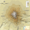
Fichier:Mount Adams bedrock topographic map-fr.svg

Taille de cet aperçu PNG pour ce fichier SVG : 589 × 600 pixels. Autres résolutions : 236 × 240 pixels | 472 × 480 pixels | 755 × 768 pixels | 1 006 × 1 024 pixels | 2 012 × 2 048 pixels | 785 × 799 pixels.
Fichier d’origine (Fichier SVG, nominalement de 785 × 799 pixels, taille : 728 kio)
Historique du fichier
Cliquer sur une date et heure pour voir le fichier tel qu'il était à ce moment-là.
| Date et heure | Vignette | Dimensions | Utilisateur | Commentaire | |
|---|---|---|---|---|---|
| actuel | 20 avril 2010 à 12:49 |  | 785 × 799 (728 kio) | Bourrichon | Lymon=>Lyman |
| 20 avril 2010 à 00:03 |  | 785 × 799 (727 kio) | Bourrichon | {{Information |Description= {{fr|Carte topographique en français du Mont Adams.}}{{de|Topographische Karte zum Mount Adams, in Französische}}{{en|Topographic map in French of [[:en:Mount Adams (Washing |
Utilisation du fichier
La page suivante utilise ce fichier :

