Fichier:Mt Bogong, Vic, jjron, 09.05.2013.jpg

Mt_Bogong,_Vic,_jjron,_09.05.2013.jpg (800 × 534 pixels, taille du fichier : 302 kio, type MIME : image/jpeg)

Ce fichier et sa description proviennent de Wikimedia Commons.

Description
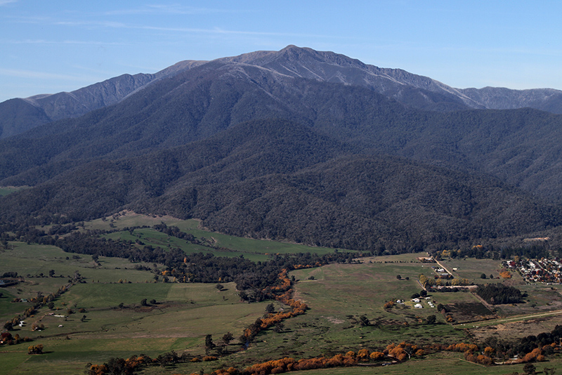
English: Mount Bogong, at 1,986 metres (6,516 ft) the highest mountain in Victoria. This is the western flank towering above the town of Mount Beauty, taken looking east from Sullivans Lookout on the Tawonga Gap Rd. Victoria, Australia.
Date
Source Travail personnel
Auteur


John O'Neill (jjron)


You can contact me about this image, its re-use, or to make a gratuity (donation) by leaving a message on my talkpage or by sending me an email.

This and/or similar images may be available from me in a higher quality or higher resolution format if required. Different terms or a fee may apply.


Autorisation
(Réutilisation de ce fichier)
Public domain Cette œuvre a été placée dans le domaine public par son auteur, John O'Neill (jjron) sur Wikipédia anglais. Ceci s’applique dans le monde entier.
Dans certains pays, ceci peut ne pas être possible ; dans ce cas :
John O'Neill (jjron) accorde à toute personne le droit d’utiliser cette œuvre dans n’importe quel but, sans aucune condition, sauf celles requises par la loi.


Plain English explanation for the use of this image


All users

I, the author, release this image into the Public Domain as Copyright Free for use worldwide.


You may:
  • copy, modify, and use this image in any way you choose.
However, I request that you follow the guidelines and moral obligations set out below.


You may be morally obliged, wherever possible, to:
  • acknowledge John O’Neill or jjron as the creator of this image.
  • acknowledge Wikipedia or Wikimedia Commons as the source of this image.
  • provide a hypertext link to this source image.
  • make a donation or payment if you reasonably expect to financially profit from use of this image.


You may encourage me to continue to contribute free high quality images by:
  • contacting me to let me know how you have found this image useful or reused it.
  • contacting me to express appreciation for donating my images to Wikipedia.
  • making a gratuity or donation to help me pay for equipment and expenses in order to continue creating and submitting free images to this project;
  • those using this image for personal, educational, non-profit, or other small scale purposes can contact me for details if you would like to make a donation.
  • commercial users may feel obliged to make a payment to me in line with usual business expenses that are otherwise avoided by use of this image.


You may NOT:
  • claim ownership, creation, copyright, or attempt to resell this image as your own work.
  • alter the licensing associated with this image. I require that freedom of usage of this image and any derivatives remains in place worldwide in perpetuity.
  • use this image in any way that suggests that I endorse or are in any way associated with you, your image usage, or your organisation without my prior consent.


You should NOT use this image in any way that:
  • promotes environmental degradation in any form.
  • is derogatory or harmful to any human individual, community, society, or culture.
  • diminishes or denigrates the sum of human knowledge.
Please contact me if you are unsure whether your usage is in breach of this guideline.


Alternatives
This and/or similar images may be available in a higher quality or higher resolution format if required.
Different licensing terms or a relicensing fee may apply for these alternative images.
Please contact me with enquiries by leaving a message on my talkpage or by sending me an email to arrange terms.
Autres versions
Lieu de la prise de vue36° 43′ 05,94″ S, 147° 07′ 52,72″ E Kartographer map based on OpenStreetMap.Voir cet endroit et d’autres images sur : OpenStreetMapinfo

Légendes

Ajoutez en une ligne la description de ce que représente ce fichier

Éléments décrits dans ce fichier

dépeint

36°43'5.938"S, 147°7'52.716"E

309 511 octet

534 pixel

800 pixel

image/jpeg

3a3f42a7684dd209019a57c4ad1bc5d29b46d374

0,003125 seconde

45 millimètre

Historique du fichier

Cliquer sur une date et heure pour voir le fichier tel qu'il était à ce moment-là.

Date et heureVignetteDimensionsUtilisateurCommentaire
actuel13 mai 2013 à 14:57Vignette pour la version du 13 mai 2013 à 14:57800 × 534 (302 kio)Jjron{{Information |description={{en|Mount Bogong, the highest mountain in Victoria, looking east from Sullivans Lookout on the Tawonga Gap Rd. Victoria, Australia.}} |date=2013-05-09 |source={{own}} |author= <br> <font size="3">'''</fo...

Usage global du fichier

Les autres wikis suivants utilisent ce fichier :

Métadonnées