Fichier:Munster Tabula Novarum Insularum 1540 UTA.jpg

Taille de cet aperçu : 777 × 600 pixels. Autres résolutions : 311 × 240 pixels | 622 × 480 pixels | 995 × 768 pixels | 1 280 × 988 pixels | 2 560 × 1 975 pixels | 3 674 × 2 835 pixels.
Fichier d’origine (3 674 × 2 835 pixels, taille du fichier : 1,93 Mio, type MIME : image/jpeg)
Ce fichier et sa description proviennent de Wikimedia Commons.
Description
| Titre |
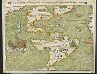
Latina: Tabula Novarum Insularum |
||||||||||||||||||||||||||
| Description |
English: Religion and politics are often closely allied, and this was especially the case in the sixteenth century. In this famous map, the Spanish flag flies prominently in the West Indies, while the Portuguese flag dominates the south Atlantic – reflecting pronouncements by Pope Alexander VI in 1493 and the Treaty of Tordesillas between Spain and Portugal of 1494. These declarations divided the non-Christian world between the two countries and charged the Portuguese and Spanish rulers with the responsibility of bringing the non-Christian inhabitants into the Catholic faith. This is reputedly the first printed map to name the Pacific Ocean and it is also among the earliest printed maps of the Western Hemisphere to show North and South America as separate but connected landmasses. The map’s creator, Münster, was a German Catholic Franciscan theologian and priest (ordained in 1512) as well as cartographer, cosmographer, humanist, mathematician, and scholar. |
||||||||||||||||||||||||||
| Date | |||||||||||||||||||||||||||
| Source | UTA Libraries Cartographic Connections: carte / texte | ||||||||||||||||||||||||||
| Créé par |
|
||||||||||||||||||||||||||
| Attribution de l’acquisition |
English: UTA Libraries Special Collections |
||||||||||||||||||||||||||
| Données géotemporelles | |||||||||||||||||||||||||||
| Lieu | Amérique | ||||||||||||||||||||||||||
| Géoréférencement | Si c'est inapproprié, définissez warp_status = skip pour masquer. | ||||||||||||||||||||||||||
| Données bibliographiques | |||||||||||||||||||||||||||
| Publication |
Geographia Universalis |
||||||||||||||||||||||||||
| Auteur |
|
||||||||||||||||||||||||||
| Lieu de publication | Bâle | ||||||||||||||||||||||||||
| Imprimé par |
|
||||||||||||||||||||||||||
| Données d'archives | |||||||||||||||||||||||||||
| Collection |
|
||||||||||||||||||||||||||
| Dimensions | hauteur : 27,5 cm ; largeur : 34,5 cm | ||||||||||||||||||||||||||
| Technique / matériaux | gravure colorée sur papier | ||||||||||||||||||||||||||
| artwork-references |
Burden The Mapping of North America, nº12 , pp. 15−17 Martin et Martin Maps of Texas and the Southwest, 1513-1900, nº2 , p. 67 |
||||||||||||||||||||||||||
.jpg)

Conditions d’utilisation

|
This file was provided to Wikimedia Commons by the University of Texas at Arlington Libraries as part of a cooperation project. The University of Texas at Arlington Libraries is part of the University of Texas at Arlington, a public research university located in Arlington, Texas.
|
|
L’auteur est mort en 1552 ; cette œuvre est donc également dans le domaine public dans tous les pays pour lesquels le droit d’auteur a une durée de vie de 100 ans ou moins après la mort de l’auteur. Cette œuvre est dans le domaine public aux États-Unis car elle a été publiée avant le 1er janvier 1929. | |
| Ce fichier a été identifié comme étant exempt de restrictions connues liées au droit d’auteur, y compris tous les droits connexes et voisins. | |
Historique du fichier
Cliquer sur une date et heure pour voir le fichier tel qu'il était à ce moment-là.
| Date et heure | Vignette | Dimensions | Utilisateur | Commentaire | |
|---|---|---|---|---|---|
| actuel | 29 janvier 2022 à 20:23 | | 3 674 × 2 835 (1,93 Mio) | Michael Barera | == {{int:filedesc}} == {{Map |title = {{la|'''''Tabula Novarum Insularum'''''}} |description = {{en|Religion and politics are often closely allied, and this was especially the case in the sixteenth century. In this famous map, the Spanish flag flies prominently in the West Indies, while the Portuguese flag dominates the south Atlantic – reflecting pronouncements by Pope Alexander VI in 1493 and the Treaty of Tordesillas between Spain and Portugal of 1494. These declaration... |
Utilisation du fichier
La page suivante utilise ce fichier :
Usage global du fichier
Les autres wikis suivants utilisent ce fichier :
- Utilisation sur bg.wikipedia.org
- Utilisation sur de.wikipedia.org
- Utilisation sur el.wikipedia.org
- Utilisation sur en.wikipedia.org
- Utilisation sur es.wikipedia.org
- Utilisation sur eu.wikipedia.org
- Utilisation sur it.wikipedia.org
- Utilisation sur ru.wikipedia.org