Fichier:Newberry Crater National Volcanic Monument, Oregon (1290856867).jpg

Fichier d’origine (1 600 × 1 200 pixels, taille du fichier : 164 kio, type MIME : image/jpeg)
Ce fichier et sa description proviennent de Wikimedia Commons.
.jpg?uselang=fr)
Description
| Description |
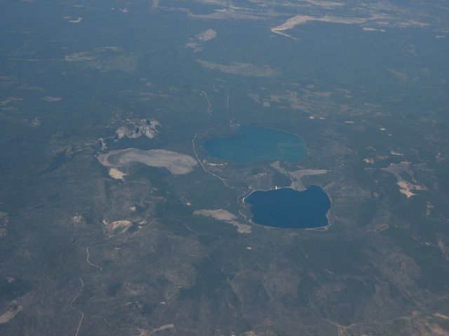
Newberry National Volcanic Monument was designated on November 5, 1990, to protect the area around the Newberry Volcano in the United States. It was created within the boundaries of the Deschutes National Forest and is managed by the U.S. Forest Service. It includes 50,000 acres (20,000 ha) of lakes, lava flows, and spectacular geologic features in central Oregon. The highest point within the monument is the summit Paulina Peak 7,985 ft (2,434 m), (2,434 m), with views of the Oregon Cascades and the high desert. Paulina Peak may be accessed by road during the summer months, and as the road is both steep and rough, with hairpin turns towards the summit, trailers or long vehicles are discouraged. The summit area of Newberry Volcano holds two alpine lakes full of trout, East Lake and Paulina Lake. The park is also home to Lava River Cave, Oregon's longest known lava tube, just south of Bend. The cave is easily accessed by U.S. Highway 97 and may be explored by lantern. Lava Butte, a 500-foot (150 m) cinder cone, is located next to U.S. Highway 97 south of Bend, next to the Lava Lands Visitor Center. The visitor center is under renovation, and is typically open during the summer. The monument also features a Lava Cast Forest, which is accessible via a 9-mile (14 km) dirt road from U.S. Highway 97. The Big Obsidian Flow, created 1,300 years ago, covers 700 acres (2.8 km2). The black, shiny obsidian field is easily accessible from good roads within the caldera, or a trail that traverses the flow. en.wikipedia.org/wiki/Newberry_National_Volcanic_Monument en.wikipedia.org/wiki/Wikipedia:Text_of_Creative_Commons_... |
| Date | |
| Source | Newberry Crater National Volcanic Monument, Oregon |
| Auteur | Ken Lund from Reno, Nevada, USA |
| Lieu de la prise de vue | | Voir cet endroit et d’autres images sur : OpenStreetMap |
|---|
.jpg¶ms=043.720001_N_-121.258506_E_globe:Earth_type:camera_source:Flickr_&language=fr)
Conditions d’utilisation
- Vous êtes libre :
- de partager – de copier, distribuer et transmettre cette œuvre
- d’adapter – de modifier cette œuvre
- Sous les conditions suivantes :
- paternité – Vous devez donner les informations appropriées concernant l'auteur, fournir un lien vers la licence et indiquer si des modifications ont été faites. Vous pouvez faire cela par tout moyen raisonnable, mais en aucune façon suggérant que l’auteur vous soutient ou approuve l’utilisation que vous en faites.
- partage à l’identique – Si vous modifiez, transformez, ou vous basez sur cette œuvre, vous devez distribuer votre contribution sous la même licence ou une licence compatible avec celle de l’original.
| Cette image a été originellement postée sur Flickr par Ken Lund à l'adresse https://flickr.com/photos/75683070@N00/1290856867. Elle a été passée en revue le 3 décembre 2015 par le robot FlickreviewR, qui a confirmé qu'elle se trouvait sous licence cc-by-sa-2.0. |
Historique du fichier
Cliquer sur une date et heure pour voir le fichier tel qu'il était à ce moment-là.
| Date et heure | Vignette | Dimensions | Utilisateur | Commentaire | |
|---|---|---|---|---|---|
| actuel | 3 décembre 2015 à 23:54 | | 1 600 × 1 200 (164 kio) | INeverCry | Transferred from Flickr via Flickr2Commons |
Utilisation du fichier
La page suivante utilise ce fichier :
Usage global du fichier
Les autres wikis suivants utilisent ce fichier :
- Utilisation sur ceb.wikipedia.org
- Utilisation sur www.wikidata.org
.jpg)