Fichier:Northern central British Isles c 700.gif
Taille de cet aperçu : 697 × 599 pixels. Autres résolutions : 279 × 240 pixels | 558 × 480 pixels | 979 × 842 pixels.
Fichier d’origine (979 × 842 pixels, taille du fichier : 407 kio, type MIME : image/gif)
Ce fichier et sa description proviennent de Wikimedia Commons.
Description

|
Ce fichier a été transféré sur Commons depuis en.wikipedia, de façon semi-automatique. Toutes les informations d'origine sont encore présentes, et il faut les vérifier. Il peut y avoir des erreurs dans la description, les catégories peuvent ne pas être les bonnes, ne faites pas confiance à cette description tant que ce bandeau est présent. Vous pouvez enlever le bandeau une fois que la description et les catégories ont été vérifiées. Vérifiez maintenant ! |
| Description |
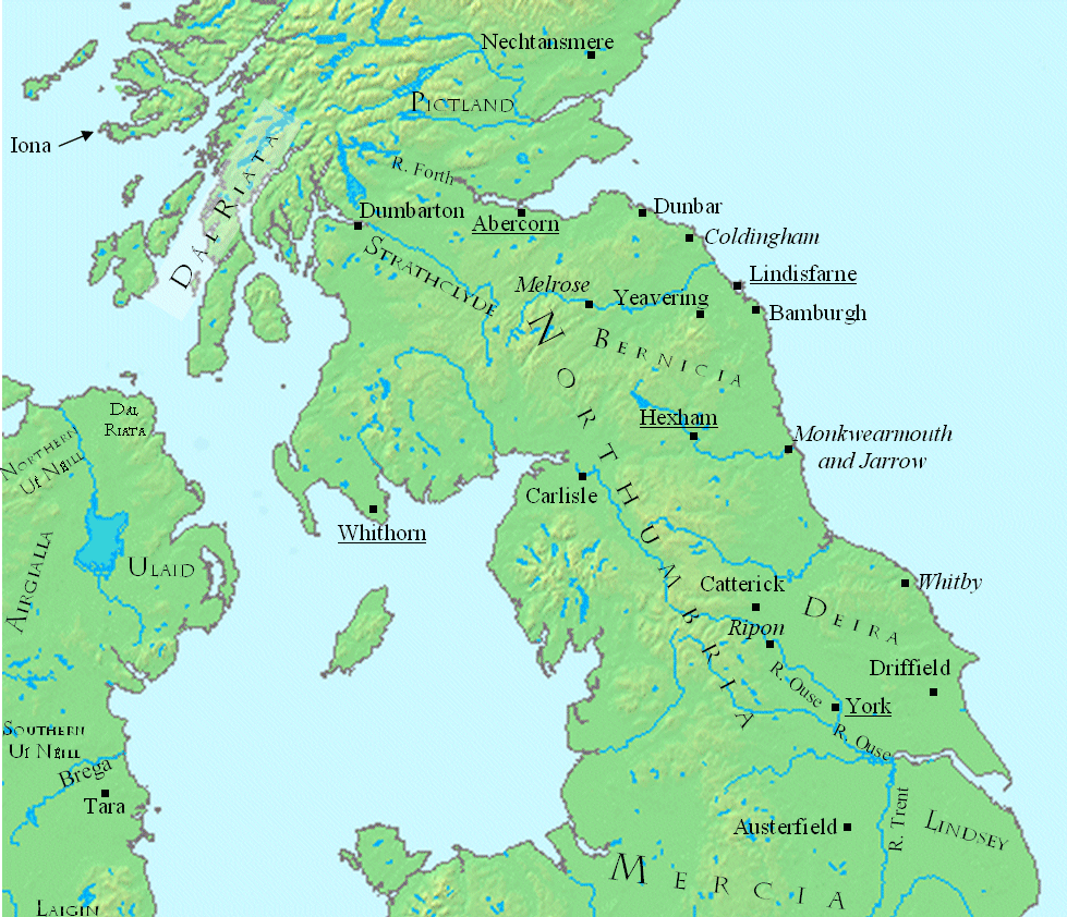
English: This is a map showing the north central British Isles in the late seventh century.
The file was created using DMIS. On that site it is stated that "We do not claim copyright on the images, so you can use them for Wikipedia." Sources include (for Great Britain) a map found in Peter Hunter Blair's "Roman Britain and Early England: 55 B.C.-871 A.D.", W.W. Norton, 1963, p. 209; and (for Ireland) on a map in Duffy's Atlas of Irish History. |
| Date | 10 février 2008 (date de téléversement originale) |
| Source | Transféré de en.wikipedia à Commons par CatMan61 utilisant CommonsHelper. |
| Auteur | Mike Christie sur Wikipédia anglais |
Conditions d’utilisation
| Cette œuvre a été placée dans le domaine public par son auteur, Mike Christie sur Wikipédia anglais. Ceci s’applique dans le monde entier. Dans certains pays, ceci peut ne pas être possible ; dans ce cas : Mike Christie accorde à toute personne le droit d’utiliser cette œuvre dans n’importe quel but, sans aucune condition, sauf celles requises par la loi. |
Journal des téléversements d’origine
La page de description originale était ici. Tous les noms d'utilisateur qui suivent se rapportent à en.wikipedia.
- 2008-02-10 22:41 Mike Christie 979×842× (416474 bytes) Move Strathclyde
- 2008-02-10 22:39 Mike Christie 979×843× (417411 bytes) Move Strathclyde further northeast
- 2008-02-10 20:43 Mike Christie 979×843× (418441 bytes) Move Strathclyde to the Clyde valley
- 2008-02-10 17:08 Mike Christie 981×842× (418505 bytes) Typo fix: Firth -> Forth
- 2008-02-10 16:44 Mike Christie 981×844× (419828 bytes) Move Strathclyde
- 2008-02-10 16:41 Mike Christie 979×843× (417131 bytes) Move Strathclyde a bit
- 2008-02-10 16:33 Mike Christie 980×843× (417179 bytes) Change Forfar -> Nechtansmere
- 2008-02-10 15:36 Mike Christie 980×842× (420235 bytes) This is a map showing the north central British Isles in the late seventh century. The file was created using [http://www.demis.nl/home/pages/home.htm DMIS]. On that site it is [http://support.demis.nl/forums/thread/1295.aspx stated] that "We do not cla
Historique du fichier
Cliquer sur une date et heure pour voir le fichier tel qu'il était à ce moment-là.
| Date et heure | Vignette | Dimensions | Utilisateur | Commentaire | |
|---|---|---|---|---|---|
| actuel | 3 janvier 2012 à 06:21 | | 979 × 842 (407 kio) | OgreBot | (BOT): Reverting to most recent version before archival |
| 3 janvier 2012 à 06:21 |  | 979 × 843 (408 kio) | OgreBot | (BOT): Uploading old version of file from en.wikipedia; originally uploaded on 2008-02-10 22:39:02 by Mike Christie | |
| 3 janvier 2012 à 06:21 |  | 979 × 843 (409 kio) | OgreBot | (BOT): Uploading old version of file from en.wikipedia; originally uploaded on 2008-02-10 20:43:53 by Mike Christie | |
| 3 janvier 2012 à 06:20 |  | 981 × 842 (409 kio) | OgreBot | (BOT): Uploading old version of file from en.wikipedia; originally uploaded on 2008-02-10 17:08:54 by Mike Christie | |
| 3 janvier 2012 à 06:20 |  | 981 × 844 (410 kio) | OgreBot | (BOT): Uploading old version of file from en.wikipedia; originally uploaded on 2008-02-10 16:44:14 by Mike Christie | |
| 3 janvier 2012 à 06:20 |  | 979 × 843 (407 kio) | OgreBot | (BOT): Uploading old version of file from en.wikipedia; originally uploaded on 2008-02-10 16:41:23 by Mike Christie | |
| 3 janvier 2012 à 06:20 |  | 980 × 843 (407 kio) | OgreBot | (BOT): Uploading old version of file from en.wikipedia; originally uploaded on 2008-02-10 16:33:49 by Mike Christie | |
| 3 janvier 2012 à 06:20 |  | 980 × 842 (410 kio) | OgreBot | (BOT): Uploading old version of file from en.wikipedia; originally uploaded on 2008-02-10 15:36:41 by Mike Christie | |
| 2 janvier 2012 à 15:19 |  | 979 × 842 (407 kio) | File Upload Bot (Magnus Manske) | {{BotMoveToCommons|en.wikipedia|year={{subst:CURRENTYEAR}}|month={{subst:CURRENTMONTHNAME}}|day={{subst:CURRENTDAY}}}} {{Information |Description={{en|This is a map showing the north central British Isles in the late seventh century. The file was create |
Utilisation du fichier
Les 2 pages suivantes utilisent ce fichier :
Usage global du fichier
Les autres wikis suivants utilisent ce fichier :
- Utilisation sur arz.wikipedia.org
- Utilisation sur de.wikipedia.org
- Utilisation sur el.wikipedia.org
- Utilisation sur en.wikipedia.org
- Utilisation sur it.wikipedia.org