Fichier:Nouvelle-France map-en.svg

Taille de cet aperçu PNG pour ce fichier SVG : 800 × 570 pixels. Autres résolutions : 320 × 228 pixels | 640 × 456 pixels | 1 024 × 730 pixels | 1 280 × 912 pixels | 2 560 × 1 824 pixels | 1 530 × 1 090 pixels.
Fichier d’origine (Fichier SVG, nominalement de 1 530 × 1 090 pixels, taille : 586 kio)
Ce fichier et sa description proviennent de Wikimedia Commons.
Description
| Description |
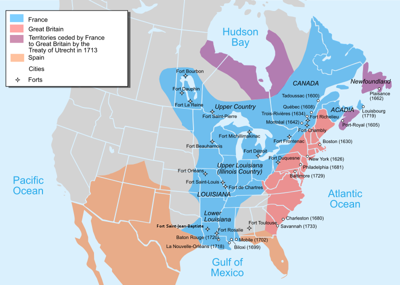
Català: Mapa de la Nova França sobre 1754-1755 English: Map of New France about 1750 using modern political boundaries Español: Mapa de la Nueva Francia cerca de 1750. Français : Carte de la Nouvelle-France vers 1754-1755 Norsk nynorsk: Kart over Ny Frankrike (ca 1754-1755) Русский: Карта Французских колоний в Америке 1750 中文(中国大陆): 1750年左右的新法兰西地图,附现代边界。 العربية : خريطة فرنسا الجديدة حوالي عام 1750 باستخدام الحدود السياسية الحديثة |
||
| Date | |||
| Source |
Travail personnel avec:
|
||
| Auteur | Pinpin | ||
| Autres versions |
[]
|


|
Ce fichier SVG contient du texte encapsulé pouvant facilement être traduit dans votre langue en utilisant n'importe quel éditeur de fichier SVG ou de texte, ou par l'outil de traduction de fichiers SVG. Pour plus d'informations, voir : A propos de la traduction des fichiers SVG. |
Cette image vectorielle non W3C-spécifiée a été créée avec Inkscape .
Conditions d’utilisation
Moi, en tant que détenteur des droits d’auteur sur cette œuvre, je la publie sous les licences suivantes :

|
Vous avez la permission de copier, distribuer et modifier ce document selon les termes de la GNU Free Documentation License version 1.2 ou toute version ultérieure publiée par la Free Software Foundation, sans sections inaltérables, sans texte de première page de couverture et sans texte de dernière page de couverture. Un exemplaire de la licence est inclus dans la section intitulée GNU Free Documentation License. |
Ce fichier est sous licence Creative Commons Attribution – Partage dans les Mêmes Conditions 3.0 (non transposée), 2.5 Générique, 2.0 Générique et 1.0 Générique.
- Vous êtes libre :
- de partager – de copier, distribuer et transmettre cette œuvre
- d’adapter – de modifier cette œuvre
- Sous les conditions suivantes :
- paternité – Vous devez donner les informations appropriées concernant l'auteur, fournir un lien vers la licence et indiquer si des modifications ont été faites. Vous pouvez faire cela par tout moyen raisonnable, mais en aucune façon suggérant que l’auteur vous soutient ou approuve l’utilisation que vous en faites.
- partage à l’identique – Si vous modifiez, transformez, ou vous basez sur cette œuvre, vous devez distribuer votre contribution sous la même licence ou une licence compatible avec celle de l’original.
Vous pouvez choisir l’une de ces licences.
Historique du fichier
Cliquer sur une date et heure pour voir le fichier tel qu'il était à ce moment-là.
| Date et heure | Vignette | Dimensions | Utilisateur | Commentaire | |
|---|---|---|---|---|---|
| actuel | 28 décembre 2022 à 00:23 | | 1 530 × 1 090 (586 kio) | Tcr25 | remove stray circle from Saskatchewan |
| 14 décembre 2022 à 18:09 |  | 1 530 × 1 090 (586 kio) | Tcr25 | plain SVG instead of Inkscape | |
| 21 septembre 2021 à 15:24 |  | 1 530 × 1 090 (590 kio) | Tcr25 | Placed Fort Rosalie in proper location; added Fort St. Jean Baptiste (Natchitoches) | |
| 10 octobre 2013 à 16:11 |  | 1 530 × 1 090 (550 kio) | Begoon | Reverted to version as of 14:02, 10 October 2013 | |
| 10 octobre 2013 à 16:08 |  | 1 530 × 1 090 (265 kio) | Begoon | revert to compare rsvg render | |
| 10 octobre 2013 à 16:02 |  | 1 530 × 1 090 (550 kio) | Begoon | revert for now - I'll play some more... | |
| 10 octobre 2013 à 15:58 |  | 1 530 × 1 090 (265 kio) | Begoon | tweak a couple of label positions | |
| 10 octobre 2013 à 15:53 |  | 1 530 × 1 090 (265 kio) | Begoon | actually - something spooky about this file ever since gradient was changed. I'm reverting to version with gradient, because it's consistent with other maps in series. Subsequent change to Fort Toulouse replicated, Mexico landmass added, layers fixed. | |
| 10 octobre 2013 à 15:10 |  | 1 530 × 1 090 (550 kio) | Begoon | cities layer is wrong - try again | |
| 10 octobre 2013 à 13:35 |  | 1 530 × 1 090 (633 kio) | Begoon | fix layers after addition |
Utilisation du fichier
La page suivante utilise ce fichier :
Usage global du fichier
Les autres wikis suivants utilisent ce fichier :
- Utilisation sur af.wikipedia.org
- Utilisation sur an.wikipedia.org
- Utilisation sur ar.wikipedia.org
- Utilisation sur arz.wikipedia.org
- Utilisation sur azb.wikipedia.org
- Utilisation sur az.wikipedia.org
- Utilisation sur bg.wikipedia.org
- Utilisation sur bn.wikipedia.org
- Utilisation sur cs.wikipedia.org
- Utilisation sur cy.wikipedia.org
- Utilisation sur da.wikipedia.org
- Utilisation sur en.wikipedia.org
- Canada–United States relations
- Louisiana
- Mississippi River
- French and Indian War
- European colonization of the Americas
- Louis XV
- History of the United States
- Queen Anne's War
- New France
- Peace of Utrecht
- Colonial history of the United States
- Military history of Canada
- History of Pennsylvania
- Northern Michigan
- Louisiana (New France)
- Spanish Texas
- French Americans
- United States
- History of Michigan
- Portal:Michigan
- Louisiana Creole people
- French immigration to Puerto Rico
- Canada
- History of St. Louis
- History of Louisiana
- Portal:Canada/Selected picture
- Portal:Pennsylvania
- Outline of the history of the United States
- Seven Years' War
Voir davantage sur l’utilisation globale de ce fichier.