Fichier:Nova totius terrarum orbis geographica ac hydrographica tabula (990027185480205171).jpg

Taille de cet aperçu : 800 × 583 pixels. Autres résolutions : 320 × 233 pixels | 640 × 467 pixels | 1 024 × 747 pixels | 1 280 × 934 pixels | 2 560 × 1 867 pixels | 9 163 × 6 683 pixels.
Fichier d’origine (9 163 × 6 683 pixels, taille du fichier : 98,71 Mio, type MIME : image/jpeg)
Ce fichier et sa description proviennent de Wikimedia Commons.
Description
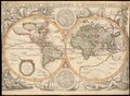
| Jodocus Hondius II : Nova Totius Terrarum Orbis Geographica ac Hydrographica Tabula
|
||||||||||||||||||||||||||||||||||||||||||||||||||||||||||||
|---|---|---|---|---|---|---|---|---|---|---|---|---|---|---|---|---|---|---|---|---|---|---|---|---|---|---|---|---|---|---|---|---|---|---|---|---|---|---|---|---|---|---|---|---|---|---|---|---|---|---|---|---|---|---|---|---|---|---|---|---|
| Artiste |
|
.jpg) | ||||||||||||||||||||||||||||||||||||||||||||||||||||||||||
| Titre |
latin : Nova Totius Terrarum Orbis Geographica ac Hydrographica Tabula Nova Totius Terrarum Orbis Geographica ac Hydrographica Tabula |
|||||||||||||||||||||||||||||||||||||||||||||||||||||||||||
| Éditeur de publication | ||||||||||||||||||||||||||||||||||||||||||||||||||||||||||||
| Type d'objet |
carte ancienne / carte manuscrite / planisphère / double hemisphere world map / Mappemondes anciennes |
|||||||||||||||||||||||||||||||||||||||||||||||||||||||||||
| Genre |
carte géographique |
|||||||||||||||||||||||||||||||||||||||||||||||||||||||||||
| Description |
Latina: Nova totius terrarum orbis geographica ac hydrographica tabula [cartographic material] / Auct Iud. Hondio.
English: The map is based on Hondius' World map of 1617. The map was the first to show Le Maire's Straits and the islands in the Pacific discovered by Le Maire and his explorations in New Guines. Hondius' map was also one of the earliest to show Hudson's Bay and the full course of th St. Lawrence in a curious configuration. |
|||||||||||||||||||||||||||||||||||||||||||||||||||||||||||
| Langue |
latin |
|||||||||||||||||||||||||||||||||||||||||||||||||||||||||||
| Date |
vers |
|||||||||||||||||||||||||||||||||||||||||||||||||||||||||||
| Date de publication |
vers |
|||||||||||||||||||||||||||||||||||||||||||||||||||||||||||
| Dimensions |
hauteur : 39 cm |
|||||||||||||||||||||||||||||||||||||||||||||||||||||||||||
| Collection |
|
|||||||||||||||||||||||||||||||||||||||||||||||||||||||||||
| Lieu actuel |
|
|||||||||||||||||||||||||||||||||||||||||||||||||||||||||||
| Lieu de publication |
Paris |
|||||||||||||||||||||||||||||||||||||||||||||||||||||||||||
| Notes | ||||||||||||||||||||||||||||||||||||||||||||||||||||||||||||
| NLI call number | W 14 | |||||||||||||||||||||||||||||||||||||||||||||||||||||||||||
| IE PID | IE13736752 | |||||||||||||||||||||||||||||||||||||||||||||||||||||||||||
| Rosetta nom de fichier | FL13746878 | |||||||||||||||||||||||||||||||||||||||||||||||||||||||||||
| identifiant NNL d'une édition (P3959) | 990027185480205171 | |||||||||||||||||||||||||||||||||||||||||||||||||||||||||||
| search Merhav catalog | planisphère, Jodocus Hondius II, Michel van Lochom, latin, 1636, Mappemondes anciennes, carte ancienne, carte manuscrite, double hemisphere world map | |||||||||||||||||||||||||||||||||||||||||||||||||||||||||||
| Autorité | ||||||||||||||||||||||||||||||||||||||||||||||||||||||||||||
| Source / photographe |
|
|||||||||||||||||||||||||||||||||||||||||||||||||||||||||||
| Autres versions | ||||||||||||||||||||||||||||||||||||||||||||||||||||||||||||
| Jpg / Tif version |
|
|||||||||||||||||||||||||||||||||||||||||||||||||||||||||||


_(cropped2).jpg)
_(cropped).jpg)
_(cropped).jpg)
_(cropped3).jpg)
_(cropped).jpg)
_(cropped4).jpg)
_(cropped5).jpg)
_(cropped6).jpg)
_(cropped7).jpg)
_(cropped9).jpg)
_(cropped10).jpg)
_(cropped11).jpg)
_(cropped12).jpg)
_(cropped8).jpg)

.jpg?uselang=fr)
Conditions d’utilisation
|
Cette œuvre est également dans le domaine public dans tous les pays pour lesquels le droit d’auteur a une durée de vie de 100 ans ou moins après la mort de l’auteur. Cette œuvre est dans le domaine public aux États-Unis car elle a été publiée avant le 1er janvier 1929. | |
| Ce fichier a été identifié comme étant exempt de restrictions connues liées au droit d’auteur, y compris tous les droits connexes et voisins. | |
Historique du fichier
Cliquer sur une date et heure pour voir le fichier tel qu'il était à ce moment-là.
| Date et heure | Vignette | Dimensions | Utilisateur | Commentaire | |
|---|---|---|---|---|---|
| actuel | 25 avril 2023 à 14:46 | | 9 163 × 6 683 (98,71 Mio) | Geagea | c:User:Rillke/bigChunkedUpload.js: {{Artwork |artist = |author = |title = |description = {{la|1=Nova totius terrarum orbis geographica ac hydrographica tabula [cartographic material] / Auct Iud. Hondio.}} {{en|1=The map is based on Hondius' World map of 1617. The map was the first to show Le Maire's Straits and the islands in the Pacific discovered by Le Maire and his explorations in New Guines. Hondiu... |
Utilisation du fichier
La page suivante utilise ce fichier :
Usage global du fichier
Les autres wikis suivants utilisent ce fichier :
- Utilisation sur he.wikipedia.org
- Utilisation sur www.wikidata.org
.jpg)