Fichier:Odoi aerial.jpg
Taille de cet aperçu : 800 × 444 pixels. Autres résolutions : 320 × 178 pixels | 640 × 355 pixels | 1 178 × 654 pixels.
Fichier d’origine (1 178 × 654 pixels, taille du fichier : 142 kio, type MIME : image/jpeg)
Ce fichier et sa description proviennent de Wikimedia Commons.
Description
en
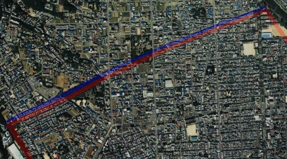
- Description: drew the site of Odoi, a barrier(red) and a moar(blue) on the aerial photo of Kyoto, Japan.
- Source: image from Country Picture Information (Color Aerial Photo) copie d'archive sur Wayback Machine resized and drew by Matsukaze.
- Date: 1988
ja
- 説明: 京都市の航空写真に御土居(赤)と堀(青)の跡を描いた。
- 出典: 国土画像情報 (カラー空中写真) copie d'archive sur Wayback Machineの写真を元にMatsukazeにより編集・作成。
Conditions d’utilisation

|
Le détenteur des droits d’auteur de ce fichier, Ministère du Territoire, des Infrastructures, des Transports et du Tourisme, autorise n’importe qui à l’utiliser pour n’importe quelle utilisation, pourvu que le détenteur des droits d’auteur soit correctement attribué. La redistribution, les œuvres dérivées, l’utilisation commerciale et toutes les autres utilisations sont autorisées. |
Attribution:
Copyright © National Land Image Information (Color Aerial Photographs), Ministry of Land, Infrastructure, Transport and Tourism
|
 |
This image is copyrighted by the Ministry of Land, Infrastructure, Transport and Tourism of Japan. For terms of use, see the stipulation to use of National Land Information (in Japanese) and message from MLIT (in Japanese and English). When you display this image on an article, include the following phrase in the description: "Made based on National Land Image Information (Color Aerial Photographs), Ministry of Land, Infrastructure, Transport and Tourism".
|
Historique du fichier
Cliquer sur une date et heure pour voir le fichier tel qu'il était à ce moment-là.
| Date et heure | Vignette | Dimensions | Utilisateur | Commentaire | |
|---|---|---|---|---|---|
| actuel | 23 juillet 2006 à 11:15 | | 1 178 × 654 (142 kio) | Matsukaze | == en == *'''Description:''' drew the site of Odoi, a barrier(red) and a moar(blue) on the aerial photo of Kyoto, Japan. *'''Source:''' image from [http://w3land.mlit.go.jp/WebGIS/ Country Picture Information (Color Aerial Photo)] resized and drew by [[Us |
Utilisation du fichier
Les 3 pages suivantes utilisent ce fichier :
Usage global du fichier
Les autres wikis suivants utilisent ce fichier :
- Utilisation sur ja.wikipedia.org