Fichier:Old Lovejoy viaduct viewed from 10th Ave ramp on 7-31-99.jpg

Taille de cet aperçu : 800 × 570 pixels. Autres résolutions : 320 × 228 pixels | 640 × 456 pixels | 1 024 × 730 pixels | 1 280 × 912 pixels | 2 560 × 1 824 pixels | 3 240 × 2 309 pixels.
Fichier d’origine (3 240 × 2 309 pixels, taille du fichier : 1,98 Mio, type MIME : image/jpeg)
Ce fichier et sa description proviennent de Wikimedia Commons.
Description
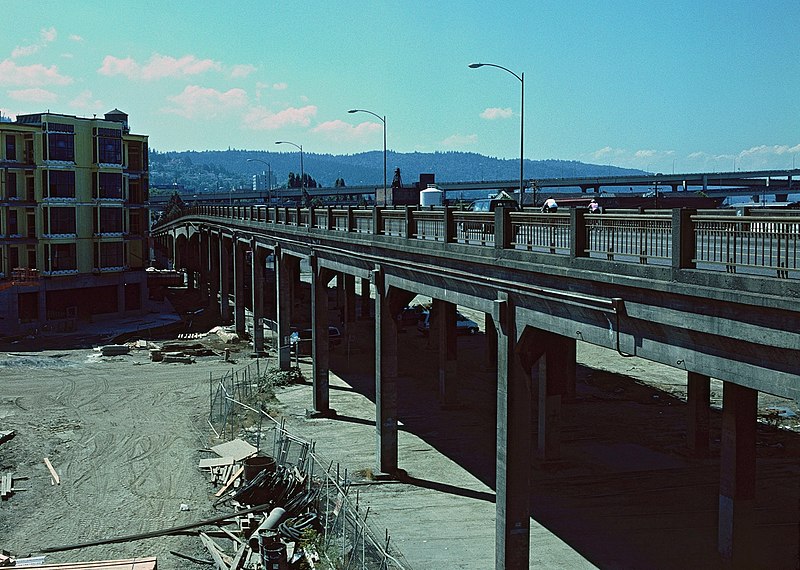
| Description | The old "Lovejoy Ramp" (which was really more of a viaduct) that connected NW 14th Avenue with the Broadway Bridge, in Portland, Oregon. It was closed on the morning of August 1, 1999 (less than 24 hours after the photo was taken) and demolished over the following months, its easternmost section (out of view here) rebuilt as a shorter ramp between 9th Avenue and the bridge. The photo is looking northwest and was taken from a connecting viaduct/ramp on 10th Avenue, which closed at the same time and was also demolished. The Lovejoy viaduct (built in 1927–28) originally carried the street over a large rail yard, but the yard was abandoned in the mid-1990s, to be replaced by dense residential development – some of the earliest of which can be seen at left (at what will be the intersection of 11th & Lovejoy). Lovejoy Street still exists at this location, but not elevated. |
| Date | |
| Source | Travail personnel |
| Auteur | Steve Morgan |
| Autorisation (Réutilisation de ce fichier) |
See below; user must attribute the photographer on any reuse. |
|
The architectural work depicted in this photograph may be covered under United States copyright law (17 USC 120(a)), which states that architectural works completed after December 1, 1990 are protected. However, architectural copyright in the United States does not include the right to prevent the making, distributing, or public display of pictures, paintings, photographs, or other pictorial representations of the work. See COM:CRT/United States#Freedom of panorama for more information.

|
| Lieu de la prise de vue | | Voir cet endroit et d’autres images sur : OpenStreetMap |
|---|
Conditions d’utilisation
Moi, en tant que détenteur des droits d’auteur sur cette œuvre, je la publie sous les licences suivantes :
Ce fichier est disponible selon les termes de la licence Creative Commons Attribution – Partage dans les Mêmes Conditions 3.0 (non transposée).
- Vous êtes libre :
- de partager – de copier, distribuer et transmettre cette œuvre
- d’adapter – de modifier cette œuvre
- Sous les conditions suivantes :
- paternité – Vous devez donner les informations appropriées concernant l'auteur, fournir un lien vers la licence et indiquer si des modifications ont été faites. Vous pouvez faire cela par tout moyen raisonnable, mais en aucune façon suggérant que l’auteur vous soutient ou approuve l’utilisation que vous en faites.
- partage à l’identique – Si vous modifiez, transformez, ou vous basez sur cette œuvre, vous devez distribuer votre contribution sous la même licence ou une licence compatible avec celle de l’original.

|
Vous avez la permission de copier, distribuer et modifier ce document selon les termes de la GNU Free Documentation License version 1.2 ou toute version ultérieure publiée par la Free Software Foundation, sans sections inaltérables, sans texte de première page de couverture et sans texte de dernière page de couverture. Un exemplaire de la licence est inclus dans la section intitulée GNU Free Documentation License. |
Vous pouvez choisir l’une de ces licences.
Historique du fichier
Cliquer sur une date et heure pour voir le fichier tel qu'il était à ce moment-là.
| Date et heure | Vignette | Dimensions | Utilisateur | Commentaire | |
|---|---|---|---|---|---|
| actuel | 8 décembre 2014 à 14:13 | | 3 240 × 2 309 (1,98 Mio) | Steve Morgan | adjusted color slightly |
| 8 décembre 2014 à 11:27 |  | 3 240 × 2 309 (1,99 Mio) | Steve Morgan | {{Information |Description=The old "Lovejoy Ramp" (which was really more of a viaduct) that connected NW 14th Avenue with the Broadway Bridge, in Portland, Oregon. It was closed on the morning of August 1, 1999 (less than 24 hours after the photo was... |
Utilisation du fichier
La page suivante utilise ce fichier :
Usage global du fichier
Les autres wikis suivants utilisent ce fichier :
- Utilisation sur en.wikipedia.org