Fichier:Old River Control Structure Complex.jpg

Taille de cet aperçu : 750 × 600 pixels. Autres résolutions : 300 × 240 pixels | 600 × 480 pixels | 960 × 768 pixels | 1 280 × 1 024 pixels | 1 500 × 1 200 pixels.
Fichier d’origine (1 500 × 1 200 pixels, taille du fichier : 1,02 Mio, type MIME : image/jpeg)
Ce fichier et sa description proviennent de Wikimedia Commons.
| Description |
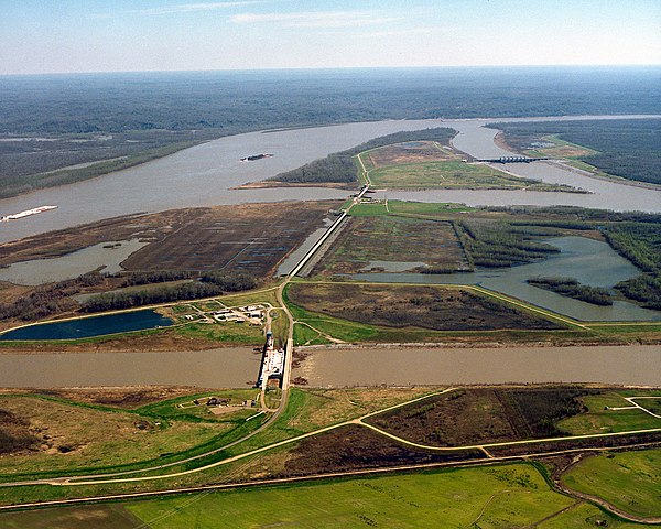
English: The Old River Control Structure at the juncture of the Mississippi River and the Atchafalaya River. In this photograph, the Mississippi River enters from the left and curves away to the right in the distance. The Atchafalaya River meets the Mississippi at three points and runs off to the bottom right. Control structures (dams) at each of the three forks of the Atchafalaya prevent most of the waters of the Mississippi from running into the Atchafalaya. The design of the structures is intended to keep 70% of the water in the Mississippi and 30% flowing into the Atchafalaya. View is to the east-southeast. The control structures are located at river mile 315 on the Mississippi (315 miles from the Gulf of Mexico). On the left of the river in this photograph is Wilkinson County in the State of Mississippi. Concordia Parish, Louisiana is on the right.
Français : La structure de régulation des eaux d'Old River, au défluent du Mississippi et de l'Atchafalaya. Sur cette photographie, le Mississippi coule depuis la gauche vers l'arrière-plan à droite. L'Atchafalaya part du Mississippi depuis trois points et coule vers l'avant-plan à droite. Les ouvrages de régulation (barrages) à chacune des branches de l'Atchafalaya empêchent la plupart des eaux du Mississippi de se déverser dans l'Atchafalaya. Ces structures sont conçues pour conserver 70% du débit dans le Mississippi et 30% dans l'Atchafalaya. La vue est vers l'est-sud-est. Les structures de régulation sont situées au point mile 315 à 506 km en amont de l'embouchure du Mississippi. Sur le côté gauche du Mississippi se trouve le comté de Wilkinson dans l'État du Mississippi. Sur le côté droit se trouve la paroisse de Concordia, en Louisiane. |
|||
| Date | ||||
| Source |
U.S. Army Corps of Engineers Digital Visual Library Image page Image description page Digital Visual Library home page |
|||
| Auteur | Michael Maples, U.S. Army Corps of Engineers | |||
| Autorisation (Réutilisation de ce fichier) |
|
|||
| Lieu | Wilkinson County, MIssissippi and Concordia County, Louisiana, USA |
| Lieu de la prise de vue | | Voir cet endroit et d’autres images sur : OpenStreetMap |
|---|
Historique du fichier
Cliquer sur une date et heure pour voir le fichier tel qu'il était à ce moment-là.
| Date et heure | Vignette | Dimensions | Utilisateur | Commentaire | |
|---|---|---|---|---|---|
| actuel | 6 avril 2007 à 05:50 | | 1 500 × 1 200 (1,02 Mio) | DanMS | {{Information | Description = {{en|The Old River Control Structure at the juncture of the Mississippi River and the Atchafalaya River. In this photograph, the Mississippi River runs along the left and curves away to the right in the distance. The Atcha |
Utilisation du fichier
Les 2 pages suivantes utilisent ce fichier :
Usage global du fichier
Les autres wikis suivants utilisent ce fichier :
- Utilisation sur bg.wikipedia.org
- Utilisation sur de.wikipedia.org
- Utilisation sur en.wikipedia.org
- Utilisation sur he.wikipedia.org
- Utilisation sur nl.wikipedia.org
- Utilisation sur pt.wikipedia.org
- Utilisation sur www.wikidata.org