Fichier:Partition of Hungary.png
Pas de plus haute résolution disponible.
Partition_of_Hungary.png (389 × 328 pixels, taille du fichier : 31 kio, type MIME : image/png)
Ce fichier et sa description proviennent de Wikimedia Commons.
Description

| Description |
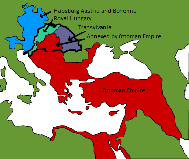
A map displaying position of the Kingdom of Hungary before 1541, and the 3 parts into which it was divided after the occupation of Buda in 1541: Royal Hungary, Eastern Hungarian kingdom, and the part that was annexed by the Ottoman Empire. en:Category:Maps of the history of Hungary |
| Date | 3 septembre 2006 (date de téléversement originale) |
| Source | Transféré de en.wikipedia à Commons. |
| Auteur | Later versions were uploaded by PANONIAN, DonatusHR at en.wikipedia. |
Conditions d’utilisation
| Cette œuvre a été placée dans le domaine public par son auteur, Esoltas sur Wikipédia anglais. Ceci s’applique dans le monde entier. Dans certains pays, ceci peut ne pas être possible ; dans ce cas : Esoltas accorde à toute personne le droit d’utiliser cette œuvre dans n’importe quel but, sans aucune condition, sauf celles requises par la loi. |
Journal des téléversements d’origine
La page de description originale était ici. Tous les noms d'utilisateur qui suivent se rapportent à en.wikipedia.
- 2007-08-12 15:14 DonatusHR 389×328×8 (38357 bytes) Vraćeno na prijašnju inačicu
- 2007-08-12 15:13 DonatusHR 389×328×8 (35596 bytes) Vraćeno na prijašnju inačicu
- 2006-10-11 10:58 PANONIAN 389×328×8 (38357 bytes) corrected image
- 2006-09-03 15:00 Esoltas 389×328×8 (35596 bytes) A map displaying the original position of the Kingdom of Hungary, and the 3 lands that became of it after the Battle of Mohács: Royal Hungary, Transylvania, and the Ottoman-occupied section.
Historique du fichier
Cliquer sur une date et heure pour voir le fichier tel qu'il était à ce moment-là.
| Date et heure | Vignette | Dimensions | Utilisateur | Commentaire | |
|---|---|---|---|---|---|
| actuel | 12 février 2016 à 19:22 | | 389 × 328 (31 kio) | Packare | better caption |
| 10 septembre 2007 à 19:58 |  | 389 × 328 (37 kio) | Sir Iain | {{Information |Description=A map displaying position of the Kingdom of Hungary before 1526, and the 3 parts into which it was divided after the Battle of Mohács: Royal Hungary, Transylvania, and the part that was annexed by the Ottoman Empire. [[:en:Ca |
Utilisation du fichier
La page suivante utilise ce fichier :
Usage global du fichier
Les autres wikis suivants utilisent ce fichier :
- Utilisation sur ar.wikipedia.org
- Utilisation sur azb.wikipedia.org
- Utilisation sur de.wikipedia.org
- Utilisation sur el.wikipedia.org
- Utilisation sur en.wikipedia.org
- Utilisation sur es.wikipedia.org
- Utilisation sur gl.wikipedia.org
- Utilisation sur hu.wikipedia.org
- Utilisation sur io.wikipedia.org
- Utilisation sur it.wikipedia.org
- Utilisation sur ja.wikipedia.org
- Utilisation sur ko.wikipedia.org
- Utilisation sur lv.wikipedia.org
- Utilisation sur nl.wikipedia.org
- Utilisation sur sk.wikipedia.org
- Utilisation sur trv.wikipedia.org
- Utilisation sur tr.wikipedia.org
- Utilisation sur uk.wikipedia.org
- Utilisation sur uz.wikipedia.org
- Utilisation sur zh.wikipedia.org