Fichier:Pinckney's Treaty line 1795.png
Taille de cet aperçu : 711 × 599 pixels. Autres résolutions : 285 × 240 pixels | 570 × 480 pixels | 911 × 768 pixels | 1 164 × 981 pixels.
Fichier d’origine (1 164 × 981 pixels, taille du fichier : 707 kio, type MIME : image/png)
Ce fichier et sa description proviennent de Wikimedia Commons.
Description
| Description |
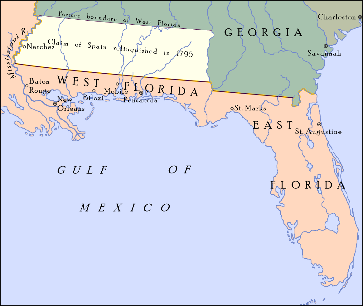
English: Map showing the boundary between the United States and Spanish Florida as set by "Pinckney's Treaty"—signed on October 27, 1795 and became effective on August 3, 1796—at 31°N; also shown is the portion of Spanish West Florida between 31°N and 32° 22′, which Spain relinquished its claim to in the treaty. On April 7, 1798, Congress organized the region as the Mississippi Territory.[1] |
| Date | |
| Source |
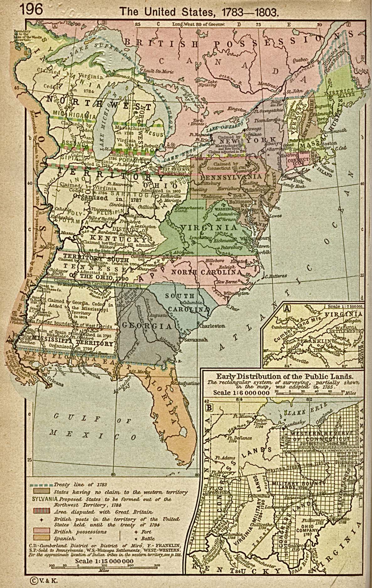
Travail personnel; map detail from The United States, 1783–1803, Perry-Castañeda Library Map Collection: Historical Maps of the United States, Perry-Castañeda Library, The University of Texas at Austin |
| Auteur | Drdpw |
Conditions d’utilisation
Moi, en tant que détenteur des droits d’auteur sur cette œuvre, je la publie sous la licence suivante :
Ce fichier est sous la licence Creative Commons Attribution – Partage dans les Mêmes Conditions 4.0 International.
- Vous êtes libre :
- de partager – de copier, distribuer et transmettre cette œuvre
- d’adapter – de modifier cette œuvre
- Sous les conditions suivantes :
- paternité – Vous devez donner les informations appropriées concernant l'auteur, fournir un lien vers la licence et indiquer si des modifications ont été faites. Vous pouvez faire cela par tout moyen raisonnable, mais en aucune façon suggérant que l’auteur vous soutient ou approuve l’utilisation que vous en faites.
- partage à l’identique – Si vous modifiez, transformez, ou vous basez sur cette œuvre, vous devez distribuer votre contribution sous la même licence ou une licence compatible avec celle de l’original.
- ↑ Pinckney's Treaty Encyclopedia Britannica
Historique du fichier
Cliquer sur une date et heure pour voir le fichier tel qu'il était à ce moment-là.
| Date et heure | Vignette | Dimensions | Utilisateur | Commentaire | |
|---|---|---|---|---|---|
| actuel | 8 août 2017 à 22:59 | | 1 164 × 981 (707 kio) | Drdpw | User created page with UploadWizard |
Utilisation du fichier
La page suivante utilise ce fichier :
Usage global du fichier
Les autres wikis suivants utilisent ce fichier :
- Utilisation sur de.wikipedia.org
- Utilisation sur en.wikipedia.org
- Utilisation sur he.wikipedia.org
- Utilisation sur it.wikipedia.org
- Utilisation sur pt.wikipedia.org
- Utilisation sur ru.wikipedia.org
- Utilisation sur vi.wikipedia.org