Fichier:Polish and Lithuanian Conflict with Prussia. 1377-1435..png
Taille de cet aperçu : 696 × 600 pixels. Autres résolutions : 279 × 240 pixels | 557 × 480 pixels | 968 × 834 pixels.
Fichier d’origine (968 × 834 pixels, taille du fichier : 182 kio, type MIME : image/png)
Ce fichier et sa description proviennent de Wikimedia Commons.
Description
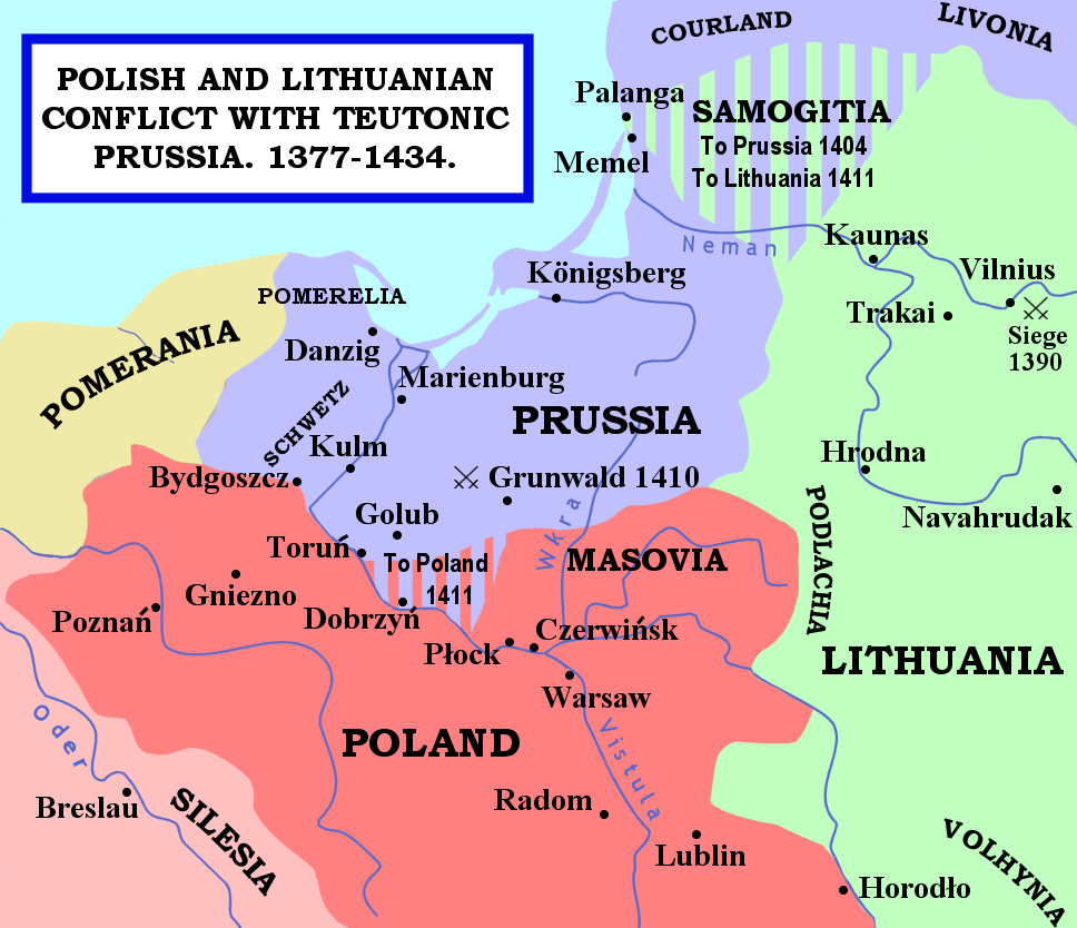
| Description | The map shows the areas of conflict between Teutonic Prussia and Poland and Lithuania during the reigns of Jogaila (Władysław II Jagiełło) and Vytautas. The areas on the borders of Prussia and Poland were particularly disputed: towns often changed hands, and Dobrzyń Land (red-and-mauve stripes) was passed back and forward as a result of various deals, treaties, and battles. Samogitia (green-and-mauve stripes) was also strongly disputed between the Teutonic Order and Lithuania, because the Knights wished to link up with the Livonian Lands further north. After the Battle of Grunwald in 1410, a series of treaties established Polish control over Dobrzyń Land and Lithuanian control over Samogitia for good, marking the beginning of the Teutonic State's decline. |
| Date | 29 janvier 2007 (date de téléversement originale) |
| Source | La source n’a pas pu être reconnue automatiquement. « Travail personnel » supposé (étant donné la revendication de droit d’auteur). |
| Auteur | L’auteur n’a pas pu être identifié automatiquement. Il est supposé qu'il s'agit de : Qp10qp (étant donné la revendication de droit d’auteur). |
Sources
- The map was outlined from this old German map: Image:Poland under Jagello.jpg.
Other references:
- The Times Concise Atlas of World History, Times Books, 1994, ISBN 0-7230-0674-1, p. 56.
- Lukowski, Jerzy and Hubert Zawadzki (2001). A Concise History of Poland. Cambridge: Cambridge University Press. ISBN 0-521-55917-0. Maps on p. 36-38.
- "Baltic Europe", in The New Cambridge Medieval History VI, ed. Michael Jones, Cambridge University Press, ISBN 0-521-36290-3. Map on p. 700.
Conditions d’utilisation
| Moi, propriétaire des droits d’auteur sur cette œuvre, la place dans le domaine public. Ceci s'applique dans le monde entier. Dans certains pays, ceci peut ne pas être possible ; dans ce cas : J’accorde à toute personne le droit d’utiliser cette œuvre dans n’importe quel but, sans aucune condition, sauf celles requises par la loi. |
Historique du fichier
Cliquer sur une date et heure pour voir le fichier tel qu'il était à ce moment-là.
| Date et heure | Vignette | Dimensions | Utilisateur | Commentaire | |
|---|---|---|---|---|---|
| actuel | 15 février 2007 à 01:22 | | 968 × 834 (182 kio) | Qp10qp | |
| 29 janvier 2007 à 09:05 |  | 968 × 834 (182 kio) | Qp10qp | The map shows the areas of conflict between Teutonic Prussia and Poland and Lithuania during the reigns of Jogaila (Władysław II Jagiełło) and Vytautas. The areas on the borders of Prussia and Poland were particularly disputed: towns changed often cha |
Utilisation du fichier
La page suivante utilise ce fichier :
Usage global du fichier
Les autres wikis suivants utilisent ce fichier :
- Utilisation sur ar.wikipedia.org
- Utilisation sur ast.wikipedia.org
- Utilisation sur az.wikipedia.org
- Utilisation sur da.wikipedia.org
- Utilisation sur en.wikipedia.org
- Utilisation sur es.wikipedia.org
- Utilisation sur gl.wikipedia.org
- Utilisation sur he.wikipedia.org
- Utilisation sur hu.wikipedia.org
- Utilisation sur id.wikipedia.org
- Utilisation sur it.wikipedia.org
- Utilisation sur ja.wikipedia.org
- Utilisation sur lt.wikibooks.org
- Utilisation sur pl.wikipedia.org
- Utilisation sur pt.wikipedia.org
- Utilisation sur sl.wikipedia.org
- Utilisation sur tr.wikipedia.org
- Utilisation sur uk.wikipedia.org
- Utilisation sur vls.wikipedia.org
- Utilisation sur www.wikidata.org
- Utilisation sur zh.wikipedia.org