Fichier:Priestley House Map.png
Pas de plus haute résolution disponible.
Priestley_House_Map.png (529 × 500 pixels, taille du fichier : 20 kio, type MIME : image/png)
Ce fichier et sa description proviennent de Wikimedia Commons.
| Description |
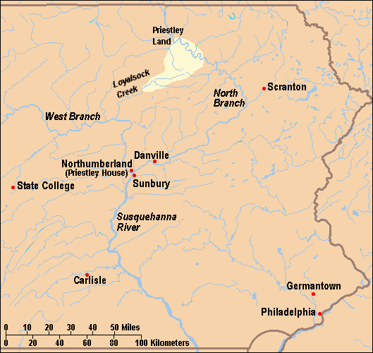
English: Map of locations mentioned in the Joseph Priestley House article in eastern Pennsylvania, United States. House is in Northumberland, Pennsylvania.
Français : Carte montrant les lieux mentionnés dans l'article concernant la Joseph Priestley House de Northumberland en Pennsylvanie. |
| Date | |
| Source | taken from US Census website [1] and modified by User:Ruhrfisch. Information for Priestley sons' land along Loyalsock Creek and North Branch of Susquehanna River based on Joseph Preistley House brochure map from the Pennsylvania Historical and Museum Commission. |
| Auteur | US Census, Ruhrfisch |
| Autorisation (Réutilisation de ce fichier) |
US Census / US Government work is public domain, my modifications licensed under the GNU Free Documentation License |
| Autres versions | Used as the larger map in both Image:Priestley House Map with inset.png and Image:Priestley House Map with inset 1.png. |

|
Vous avez la permission de copier, distribuer et modifier ce document selon les termes de la GNU Free Documentation License version 1.2 ou toute version ultérieure publiée par la Free Software Foundation, sans sections inaltérables, sans texte de première page de couverture et sans texte de dernière page de couverture. Un exemplaire de la licence est inclus dans la section intitulée GNU Free Documentation License. |
| Ce fichier est disponible selon les termes de la licence Creative Commons Attribution – Partage dans les Mêmes Conditions 3.0 (non transposée). | ||
| ||
| Ce bandeau de licence a été ajouté à ce fichier dans le cadre de la procédure de mise à jour des licences des images sous GFDL. |
Historique du fichier
Cliquer sur une date et heure pour voir le fichier tel qu'il était à ce moment-là.
| Date et heure | Vignette | Dimensions | Utilisateur | Commentaire | |
|---|---|---|---|---|---|
| actuel | 11 avril 2009 à 01:32 | | 529 × 500 (20 kio) | Mahahahaneapneap | Compressed |
| 22 janvier 2008 à 22:13 |  | 529 × 500 (33 kio) | Ruhrfisch | Add Carlisle, PA dot and label (as now in the article), all other information the same | |
| 11 janvier 2008 à 18:47 |  | 529 × 500 (33 kio) | Ruhrfisch | Removed "PENNSYLVANIA", added 10s to miles scale and 20s to kilometers scale, all other information the same | |
| 11 janvier 2008 à 06:21 |  | 529 × 500 (33 kio) | Ruhrfisch | Move Danville label west to keep North Branch clearly displayed, all other info the same. | |
| 11 janvier 2008 à 06:05 |  | 529 × 500 (33 kio) | Ruhrfisch | {{Information| |Description= Map of locations mentioned in the Joseph Priestley House article in eastern Pennsylvania, United States. House is in Northumberland, Pennsylvania. |Source= taken from US Census website [http://fac |
Utilisation du fichier
La page suivante utilise ce fichier :
Usage global du fichier
Les autres wikis suivants utilisent ce fichier :
- Utilisation sur en.wikipedia.org
- Joseph Priestley House
- Talk:Joseph Priestley House/Archive 1
- User:Ruhrfisch/map
- User talk:Wadewitz/Archive 23
- User talk:Doc glasgow/Feb 08
- User talk:Doncram/Archive 2
- Wikipedia talk:WikiProject National Register of Historic Places/Archive 6
- User talk:Karanacs/Archive 4
- User talk:Epbr123/Archive 2
- User:Gerry D/archive7
- User talk:Coldupnorth/Archive9
- User talk:Daniel Case/Archive 12/7/2007-3/12/2008
- User talk:Yllosubmarine/Archive 4
- User talk:Ben MacDui/Archive 5
- Wikipedia talk:WikiProject Pennsylvania/Archive 3