Fichier:Reichskommissariat Ostland Administrative.png

Taille de cet aperçu : 415 × 599 pixels. Autres résolutions : 166 × 240 pixels | 333 × 480 pixels | 532 × 768 pixels | 710 × 1 024 pixels | 1 420 × 2 048 pixels | 2 856 × 4 120 pixels.
Fichier d’origine (2 856 × 4 120 pixels, taille du fichier : 1,89 Mio, type MIME : image/png)
Ce fichier et sa description proviennent de Wikimedia Commons.
Description
| Description |
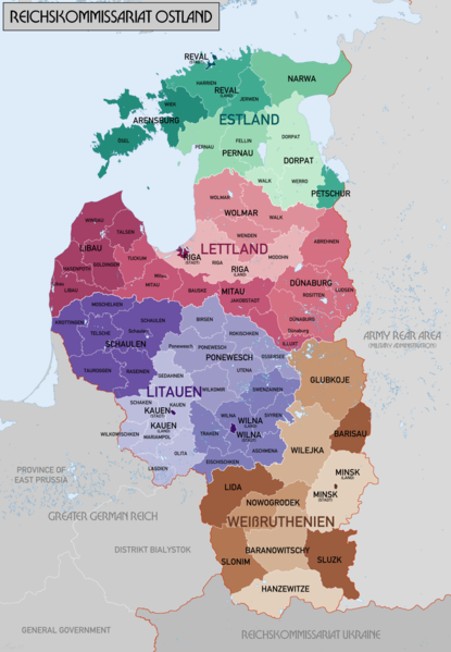
English: Administrative Map of Reichskommissariat Ostland |
| Date | |
| Source | Travail personnel |
| Auteur | XrysD |
| Autres versions |
Œuvres dérivées de ce fichier : Gen Okrug Belarus Administrative.png Œuvres dérivées de ce fichier : Generalbezirk Lettland.png |
Conditions d’utilisation
Moi, en tant que détenteur des droits d’auteur sur cette œuvre, je la publie sous les licences suivantes :

|
Vous avez la permission de copier, distribuer et modifier ce document selon les termes de la GNU Free Documentation License version 1.2 ou toute version ultérieure publiée par la Free Software Foundation, sans sections inaltérables, sans texte de première page de couverture et sans texte de dernière page de couverture. Un exemplaire de la licence est inclus dans la section intitulée GNU Free Documentation License. |
| Ce fichier est disponible selon les termes de la licence Creative Commons Attribution – Partage dans les Mêmes Conditions 3.0 (non transposée). | ||
| ||
| Ce bandeau de licence a été ajouté à ce fichier dans le cadre de la procédure de mise à jour des licences des images sous GFDL. |
| Copyleft : cette œuvre d’art est libre ; vous pouvez la redistribuer ou la modifier selon les termes de la licence Art Libre. Vous trouverez un exemplaire de cette licence sur le site Copyleft Attitude ainsi que sur d’autres sites. |
Vous pouvez choisir l’une de ces licences.
Historique du fichier
Cliquer sur une date et heure pour voir le fichier tel qu'il était à ce moment-là.
| Date et heure | Vignette | Dimensions | Utilisateur | Commentaire | |
|---|---|---|---|---|---|
| actuel | 20 février 2018 à 22:46 | | 2 856 × 4 120 (1,89 Mio) | XrysD | Changed map colours to use ColorBrewer Wikipedia recommended palette. |
| 20 février 2018 à 15:33 |  | 2 856 × 4 120 (1,86 Mio) | XrysD | New version reduced legibility - e.g. borders in Riga District now invisible. | |
| 15 février 2018 à 23:18 |  | 2 856 × 4 120 (2,62 Mio) | 1970gemini | fiat lux | |
| 11 mai 2017 à 19:47 |  | 2 856 × 4 120 (1,86 Mio) | XrysD | Fixed typo in source graphic and re-rendered output PNG to avoid loss of quality due to editing render rather than source. | |
| 11 mai 2017 à 16:58 |  | 2 856 × 4 120 (1,92 Mio) | Намѣсникъ | name of Dünaburg (not Dünaberg) corrected | |
| 22 avril 2017 à 18:25 |  | 2 856 × 4 120 (1,71 Mio) | XrysD | Added missing labels | |
| 22 avril 2017 à 17:54 |  | 2 856 × 4 120 (1,69 Mio) | XrysD | Completely new version. Source map data: [Karte des Deutschen Reiches (Grossblatter) 1:100k, Mapa Administracyjna Rzeczypospolitej Polska 1:300k, Verwaltungskarte_Weissruthenien_u.Ssmolensk_1M_Ausg.1_(B)_X.1942, 1:500k, Strassenkarte der Baltischen Lae... | |
| 1 septembre 2015 à 18:50 |  | 1 548 × 2 139 (1,04 Mio) | Poeticbent | added missing subdivisions | |
| 20 septembre 2008 à 00:03 |  | 1 548 × 2 139 (962 kio) | XrysD | {{Information |Description={{en|1=Administrative Map of Reichskommissariat Ostland}} |Source=Own work by uploader |Author=XrysD |Date=19/09/2008 |Permission= |other_versions= }} <!--{{ImageUpload|full}}--> |
Utilisation du fichier
Les 9 pages suivantes utilisent ce fichier :
- Hermann Riecken
- Histoire de la Biélorussie
- Histoire de la Lituanie
- Occupation de l'Union soviétique par l'Allemagne pendant la Seconde Guerre mondiale
- Occupation de la Lituanie pendant la Seconde Guerre mondiale
- Reichskommissariat
- Reichskommissariat Ostland
- Shoah en Lituanie
- Wikipédia:Atelier graphique/Cartes/Archives/avril 2014
Usage global du fichier
Les autres wikis suivants utilisent ce fichier :
- Utilisation sur ar.wikipedia.org
- Utilisation sur az.wikipedia.org
- Utilisation sur be-tarask.wikipedia.org
- Utilisation sur be.wikipedia.org
- Utilisation sur bs.wikipedia.org
- Utilisation sur ca.wikipedia.org
- Utilisation sur cs.wikipedia.org
- Utilisation sur da.wikipedia.org
- Utilisation sur de.wikipedia.org
- Utilisation sur en.wikipedia.org
- Reichskommissariat Ostland
- Demographic history of the Vilnius region
- Reichskommissariat
- German occupation of Lithuania during World War II
- Generalbezirk Litauen
- Wikipedia:WikiProject Military history/News/August 2012/Op-ed
- Generalbezirk Estland
- Generalbezirk Lettland
- Walther Schröder
- Karl Schäfer (SS-Brigadeführer)
- Generalbezirk Weißruthenien
- Talk:Lithuanian Territorial Defense Force/Archive 1
- User:Falcaorib/Poland-Lithuania
- User:Falcaorib/Baltic States
- User:Falcaorib/Belarus
- Utilisation sur es.wikipedia.org
- Utilisation sur et.wikipedia.org
Voir davantage sur l’utilisation globale de ce fichier.