Fichier:Rif Dimashq offensive (March 2013).svg

Taille de cet aperçu PNG pour ce fichier SVG : 800 × 523 pixels. Autres résolutions : 320 × 209 pixels | 640 × 419 pixels | 1 024 × 670 pixels | 1 280 × 837 pixels | 2 560 × 1 674 pixels | 1 856 × 1 214 pixels.
Fichier d’origine (Fichier SVG, nominalement de 1 856 × 1 214 pixels, taille : 13,07 Mio)
Ce fichier et sa description proviennent de Wikimedia Commons.
.svg?uselang=fr)
Description
| Description |
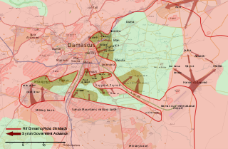
English: Map of the March 2013 Rif Dimashq offensive, showing frontlines before the offensive, and the current strategic situation.
العربية: خريطة تظهر هجوم مارس 2013 على دمشق، تظهر الخريطة خطوط الجبهات قبل الهجوم، و الوضع الاستراتيجي منذ سبتمبر 2013. |
| Date | |
| Source | Travail personnel, OpenStreetMap |
| Auteur | MrPenguin20 |
Conditions d’utilisation
| Ce travail contient des informations issues de OpenStreetMap mises à disposition sous les termes de la Licence Open Database (ODbL).
L'ODbL n'exige aucune licence en particulier pour les cartes produites à partir de données placées sous l'ODbL. Avant le 1er août 2020, les tuiles des cartes produites par la Fondation OpenStreetMap étaient placées sous la licence CC-BY-SA-2.0. Les cartes produites par d'autres personnes peuvent être placées sous des licences différentes. |
Moi, en tant que détenteur des droits d’auteur sur cette œuvre, je la publie sous la licence suivante :
Ce fichier est disponible selon les termes de la licence Creative Commons Attribution – Partage dans les Mêmes Conditions 3.0 (non transposée).
- Vous êtes libre :
- de partager – de copier, distribuer et transmettre cette œuvre
- d’adapter – de modifier cette œuvre
- Sous les conditions suivantes :
- paternité – Vous devez donner les informations appropriées concernant l'auteur, fournir un lien vers la licence et indiquer si des modifications ont été faites. Vous pouvez faire cela par tout moyen raisonnable, mais en aucune façon suggérant que l’auteur vous soutient ou approuve l’utilisation que vous en faites.
- partage à l’identique – Si vous modifiez, transformez, ou vous basez sur cette œuvre, vous devez distribuer votre contribution sous la même licence ou une licence compatible avec celle de l’original.
Historique du fichier
Cliquer sur une date et heure pour voir le fichier tel qu'il était à ce moment-là.
.svg&dir=prev)
.svg&offset=20130903001601)
.svg&offset=&limit=20)
.svg&offset=&limit=50)
.svg&offset=&limit=100)
.svg&offset=&limit=250)
.svg&offset=&limit=500)
| Date et heure | Vignette | Dimensions | Utilisateur | Commentaire | |
|---|---|---|---|---|---|
| actuel | 6 août 2018 à 19:27 | | 1 856 × 1 214 (13,07 Mio) | Rr016 | Filled in empty spaces, as per AlAboud83's request |
| 7 décembre 2013 à 18:55 |  | 1 856 × 1 214 (13,06 Mio) | EkoGraf | This map is for the offensive that lasted until late August. A map for the development of the offensive that started in September already exists | |
| 13 novembre 2013 à 21:04 |  | 1 485 × 971 (11,56 Mio) | U5K0 | hejeira to loyalists per enwp | |
| 7 novembre 2013 à 23:57 |  | 1 485 × 971 (11,56 Mio) | U5K0 | Al-Sabinah to loyalists per enwp article | |
| 26 octobre 2013 à 11:57 |  | 1 485 × 971 (11,56 Mio) | U5K0 | Hatetat al-Turkman per english wp article | |
| 9 octobre 2013 à 19:37 |  | 1 485 × 971 (10,4 Mio) | Ahmadac~commonswiki | Updated map based on https://en.wikipedia.org/wiki/Template:Syrian_civil_war_detailed_map - Also added Husseiniyah under SAA control. http://www.al-akhbar.com/node/192916 | |
| 23 septembre 2013 à 02:12 |  | 1 856 × 1 214 (13,06 Mio) | MrPenguin20 | Uploaded correct version. | |
| 23 septembre 2013 à 02:06 |  | 1 856 × 1 214 (13,06 Mio) | MrPenguin20 | Marked several military bases. Marked Sheba'a. Daraya contested. | |
| 15 septembre 2013 à 15:34 |  | 1 856 × 1 214 (9,33 Mio) | MrPenguin20 | The M5 highway under the control of SAA before the attack. M1 also under government control. Al-Sabinah, Hujayrah, Deir Salman, Yalda, Babbila and Beit sahem are contested. Hatitat al-Turkuman and Deir al-Asafir under attack from SAA. Qadam also cont... | |
| 3 septembre 2013 à 02:16 |  | 1 856 × 1 214 (9,36 Mio) | MrPenguin20 | Jamraya & surrounding area under government control according to [https://www.facebook.com/photo.php?fbid=575156802521211&set=a.224155897621305.50803.217139528322942&type=1 new map]. |
Utilisation du fichier
Les 2 pages suivantes utilisent ce fichier :
Usage global du fichier
Les autres wikis suivants utilisent ce fichier :
- Utilisation sur ar.wikipedia.org
- Utilisation sur bg.wikipedia.org
- Utilisation sur en.wikipedia.org
- Utilisation sur es.wikipedia.org
- Utilisation sur he.wikipedia.org
- Utilisation sur it.wikipedia.org
- Utilisation sur pl.wikipedia.org
- Utilisation sur ru.wikipedia.org
- Utilisation sur tr.wikipedia.org
- Utilisation sur www.wikidata.org
- Utilisation sur zh.wikipedia.org
.svg)