Fichier:SAA Southern Africa network map.svg

Taille de cet aperçu PNG pour ce fichier SVG : 600 × 400 pixels. Autres résolutions : 320 × 213 pixels | 640 × 427 pixels | 1 024 × 683 pixels | 1 280 × 853 pixels | 2 560 × 1 707 pixels.
Fichier d’origine (Fichier SVG, nominalement de 600 × 400 pixels, taille : 146 kio)
Ce fichier et sa description proviennent de Wikimedia Commons.
Description
| Description |
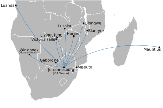
English: Map of the Southern Africa route network of South African Airways, not including its affiliates. Based on the February 2010 SAA timetable. See also File:SAA domestic network map.svg for domestic routes, and File:SAA international network map.svg for other international routes. |
| Date | |
| Source | Own work by uploader; country basemap from File:BlankMap-Africa.svg. |
| Auteur | Htonl |
| Autres versions | Œuvres dérivées de ce fichier : African quadripoint.svg |
Conditions d’utilisation
Moi, en tant que détenteur des droits d’auteur sur cette œuvre, je la publie sous les licences suivantes :
Ce fichier est disponible selon les termes de la licence Creative Commons Attribution – Partage dans les Mêmes Conditions 3.0 (non transposée).
- Vous êtes libre :
- de partager – de copier, distribuer et transmettre cette œuvre
- d’adapter – de modifier cette œuvre
- Sous les conditions suivantes :
- paternité – Vous devez donner les informations appropriées concernant l'auteur, fournir un lien vers la licence et indiquer si des modifications ont été faites. Vous pouvez faire cela par tout moyen raisonnable, mais en aucune façon suggérant que l’auteur vous soutient ou approuve l’utilisation que vous en faites.
- partage à l’identique – Si vous modifiez, transformez, ou vous basez sur cette œuvre, vous devez distribuer votre contribution sous la même licence ou une licence compatible avec celle de l’original.

|
Vous avez la permission de copier, distribuer et modifier ce document selon les termes de la GNU Free Documentation License version 1.2 ou toute version ultérieure publiée par la Free Software Foundation, sans sections inaltérables, sans texte de première page de couverture et sans texte de dernière page de couverture. Un exemplaire de la licence est inclus dans la section intitulée GNU Free Documentation License. |
Vous pouvez choisir l’une de ces licences.
Historique du fichier
Cliquer sur une date et heure pour voir le fichier tel qu'il était à ce moment-là.
| Date et heure | Vignette | Dimensions | Utilisateur | Commentaire | |
|---|---|---|---|---|---|
| actuel | 20 février 2010 à 23:15 | | 600 × 400 (146 kio) | Htonl | text to paths |
| 20 février 2010 à 23:12 |  | 600 × 400 (66 kio) | Htonl | remove affiliates | |
| 8 juillet 2009 à 00:41 |  | 600 × 400 (290 kio) | Htonl | {{Information |Description={{en|1=Map of the Southern Africa route network of w:South African Airways and its affiliates w:South African Express and w:Airlink (all flights coded SAxxxx). See also File:SAA_domestic_network_map.svg for d |
Utilisation du fichier
Aucune page n’utilise ce fichier.
Usage global du fichier
Les autres wikis suivants utilisent ce fichier :
- Utilisation sur af.wikipedia.org
- Utilisation sur es.wikipedia.org
- Utilisation sur incubator.wikimedia.org