Fichier:SDLIMITS.jpg

Fichier d’origine (1 200 × 927 pixels, taille du fichier : 165 kio, type MIME : image/jpeg)
Ce fichier et sa description proviennent de Wikimedia Commons.
Description
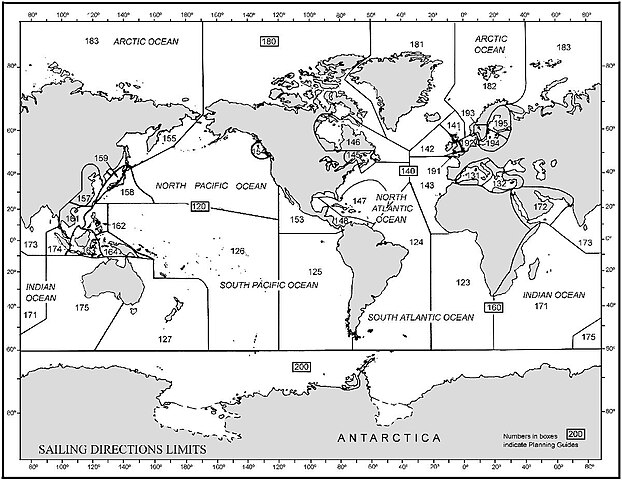
This Graphic is taken from http://msi.nga.mil/MSISiteContent/StaticFiles/Images/SDLIMITS.jpg
Graphic overview (world map) with limits of the Sailing Directions volumes of the U.S. NIMA (National Imagery and Mapping Agency) which can be downloaded starting at page http://permanent.access.gpo.gov/websites/pollux/pollux.nss.nima.mil/NAV_PUBS/SD/
The sailing directions can be found with this URL: [1] (replace the last three digits by the actual number)
Conditions d’utilisation
Ce média est dans le domaine public des États-Unis d’Amérique car son auteur est l’administration américaine comme précisé dans le code fédéral au Titre 17, Chapitre 1, Section 105. Pour en savoir plus : droit d’auteur.
Attention : Ceci ne concerne que le travail du Gouvernement Fédéral et pas celui des États, ou d’une autre subdivision géographique ou politique du pays.
|
 | |
| Ce fichier a été identifié comme étant exempt de restrictions connues liées au droit d’auteur, y compris tous les droits connexes et voisins. | ||
Historique du fichier
Cliquer sur une date et heure pour voir le fichier tel qu'il était à ce moment-là.
| Date et heure | Vignette | Dimensions | Utilisateur | Commentaire | |
|---|---|---|---|---|---|
| actuel | 10 octobre 2006 à 22:50 | | 1 200 × 927 (165 kio) | Ratzer | Graphic overview (world map) with limits of the Sailing Directions volumes of the U.S. NIMA (National Imagery and Mapping Agency) which can be downloaded starting at page http://permanent.access.gpo.gov/websites/pollux/pollux.nss.nima.mil/NAV_PUBS/SD/ |
Utilisation du fichier
La page suivante utilise ce fichier :
Usage global du fichier
Les autres wikis suivants utilisent ce fichier :
- Utilisation sur ca.wikipedia.org
- Utilisation sur de.wikipedia.org
- Utilisation sur en.wikipedia.org
- Utilisation sur es.wikipedia.org
- Utilisation sur lv.wikipedia.org