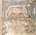
Fichier:Shimabara-Battle-Map-c17th-century.png

Taille de cet aperçu : 614 × 600 pixels. Autres résolutions : 246 × 240 pixels | 491 × 480 pixels | 786 × 768 pixels | 1 048 × 1 024 pixels | 2 097 × 2 048 pixels | 3 195 × 3 121 pixels.
Fichier d’origine (3 195 × 3 121 pixels, taille du fichier : 16,15 Mio, type MIME : image/png)
Historique du fichier
Cliquer sur une date et heure pour voir le fichier tel qu'il était à ce moment-là.
| Date et heure | Vignette | Dimensions | Utilisateur | Commentaire | |
|---|---|---|---|---|---|
| actuel | 3 décembre 2021 à 15:22 |  | 3 195 × 3 121 (16,15 Mio) | Artanisen | Uploaded a work by Unknown (created circa 17th century) from Yanagawa Ancient Archives - https://www.city.yanagawa.fukuoka.jp/blog-buka/2020/_7900/_7933.html with UploadWizard |
Utilisation du fichier
Les 4 pages suivantes utilisent ce fichier :
Usage global du fichier
Les autres wikis suivants utilisent ce fichier :
- Utilisation sur ar.wikipedia.org
- Utilisation sur azb.wikipedia.org
- Utilisation sur ca.wikipedia.org
- Utilisation sur de.wikipedia.org
- Utilisation sur en.wikipedia.org
- Utilisation sur es.wikipedia.org
- Utilisation sur he.wikipedia.org
- Utilisation sur hu.wikipedia.org
- Utilisation sur id.wikipedia.org
- Utilisation sur it.wikipedia.org
- Utilisation sur ja.wikipedia.org
- Utilisation sur lt.wikipedia.org
- Utilisation sur no.wikipedia.org
- Utilisation sur oc.wikipedia.org
- Utilisation sur pl.wikipedia.org
- Utilisation sur pt.wikipedia.org
- Utilisation sur ro.wikipedia.org
- Utilisation sur ru.wikipedia.org
- Utilisation sur sv.wikipedia.org
- Utilisation sur th.wikipedia.org
- Utilisation sur tr.wikipedia.org
- Utilisation sur vi.wikipedia.org
- Utilisation sur www.wikidata.org
- Utilisation sur zh.wikipedia.org