Fichier:Sino-Indian Geography.png
Fichier d’origine (918 × 648 pixels, taille du fichier : 1,36 Mio, type MIME : image/png)
Ce fichier et sa description proviennent de Wikimedia Commons.
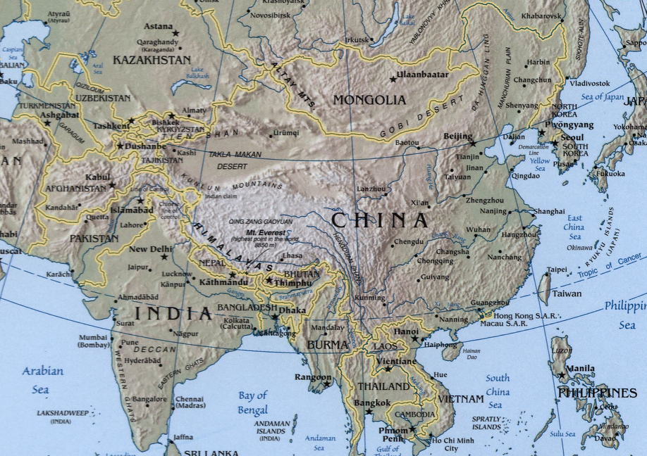
A map showing the geography of the Sino-Indian region.
A physical map with relief showing shading. Scale 1:48,000,000 ; Azimuthal equal-area projection (W 50--W 1650/N 880--S 180).
Cropped from a larger map showing Asia - which may be found on the Library of Congress website (the source image) or alternatively on the CIA World Factbook.
Image created and published by the Central Intelligence Agency of the United States of America in 2004.
Note
The land border between the China and India over Arunachal Pradesh / South Tibet reflects actual control, without dotted line showing claims
Cette image est dans le domaine public parce que son contenu provient du World Factbook, édité par la Central Intelligence Agency des États-Unis d’Amérique.
|
 |
Historique du fichier
Cliquer sur une date et heure pour voir le fichier tel qu'il était à ce moment-là.
| Date et heure | Vignette | Dimensions | Utilisateur | Commentaire | |
|---|---|---|---|---|---|
| actuel | 22 novembre 2004 à 21:32 | | 918 × 648 (1,36 Mio) | OldakQuill | |
| 22 novembre 2004 à 11:38 |  | 354 × 350 (98 kio) | OldakQuill | A map showing the geography of the Sino-Indian region. {{pd}} |
Utilisation du fichier
Les 2 pages suivantes utilisent ce fichier :
Usage global du fichier
Les autres wikis suivants utilisent ce fichier :
- Utilisation sur ar.wikipedia.org
- Utilisation sur bn.wikipedia.org
- Utilisation sur de.wikipedia.org
- Utilisation sur en.wikipedia.org
- Utilisation sur fa.wikipedia.org
- Utilisation sur ha.wikipedia.org
- Utilisation sur hi.wikipedia.org
- Utilisation sur hy.wikipedia.org
- Utilisation sur id.wikipedia.org
- Utilisation sur mn.wikipedia.org
- Utilisation sur ms.wikipedia.org
- Utilisation sur nl.wikipedia.org
- Utilisation sur pnb.wikipedia.org
- Utilisation sur ru.wikipedia.org
- Utilisation sur sr.wikipedia.org
- Utilisation sur tr.wikipedia.org
- Utilisation sur uk.wikipedia.org
- Utilisation sur ur.wikipedia.org
- Utilisation sur uz.wikipedia.org
- Utilisation sur www.wikidata.org
- Utilisation sur zh.wikipedia.org