Fichier:Somerset UK relief location map.jpg

Taille de cet aperçu : 800 × 505 pixels. Autres résolutions : 320 × 202 pixels | 640 × 404 pixels | 1 024 × 647 pixels | 1 280 × 808 pixels | 2 019 × 1 275 pixels.
Fichier d’origine (2 019 × 1 275 pixels, taille du fichier : 367 kio, type MIME : image/jpeg)
Ce fichier et sa description proviennent de Wikimedia Commons.
| Description |
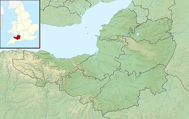
Relief map of Somerset, UK. Equirectangular map projection on WGS 84 datum, with N/S stretched 155% Geographic limits:
|
| Date | |
| Source |
|
| Auteur | Nilfanion, created using Ordnance Survey data |
| Autorisation (Réutilisation de ce fichier) |
Ce fichier est disponible selon les termes de la licence Creative Commons Attribution – Partage dans les Mêmes Conditions 3.0 (non transposée). Attribution: Contains Ordnance Survey data © Crown copyright and database right
|
| Autres versions | File:Somerset UK district map (blank).svg - Blank map |
.svg)
Historique du fichier
Cliquer sur une date et heure pour voir le fichier tel qu'il était à ce moment-là.
| Date et heure | Vignette | Dimensions | Utilisateur | Commentaire | |
|---|---|---|---|---|---|
| actuel | 29 novembre 2011 à 03:53 | | 2 019 × 1 275 (367 kio) | Nilfanion | {{Information |Description=Relief map of Somerset, UK. Equirectangular map projection on WGS 84 datum, with N/S stretched 155% Geographic limits: *West: 3.96W *East: 2.12W *North: 51.55N *South: 50.80N |Source=[[w:Ordnance Survey|Ordnance |
Utilisation du fichier
Les 12 pages suivantes utilisent ce fichier :
Usage global du fichier
Les autres wikis suivants utilisent ce fichier :
- Utilisation sur ar.wikipedia.org
- Utilisation sur arz.wikipedia.org
- Utilisation sur bg.wikipedia.org
- Utilisation sur bn.wikipedia.org
- Utilisation sur ceb.wikipedia.org
- Utilisation sur en.wikipedia.org
- Battle of Lansdowne
- Battle of Sedgemoor
- River Tone
- Chew Valley Lake
- Hunstrete Lake
- Orchardleigh Lake
- Battle of Langport
- Cheddar Reservoir
- Blagdon Lake
- Litton Reservoirs
- Chew Magna Reservoir
- Emborough
- Wimbleball Lake
- Ashford Reservoir
- River Cam (Somerset)
- Clatworthy Reservoir
- Durleigh reservoir
- Buildings and architecture of Bath
- Ham Wall
- Knowle Hill
- Weston-super-Mare Lifeboat Station
- Chard Reservoir
- Hawkridge Reservoir
- Sutton Bingham Reservoir
- Otterhead Lakes
- Minehead Lifeboat Station
- Burnham-on-Sea Lifeboat Station
- Burnham Area Rescue Boat
- Brent Knoll
- Luxhay Reservoir
Voir davantage sur l’utilisation globale de ce fichier.