Fichier:Sunset from the ISS.JPG
Fichier d’origine (4 256 × 2 829 pixels, taille du fichier : 391 kio, type MIME : image/jpeg)
Ce fichier et sa description proviennent de Wikimedia Commons.
Description
| Description |
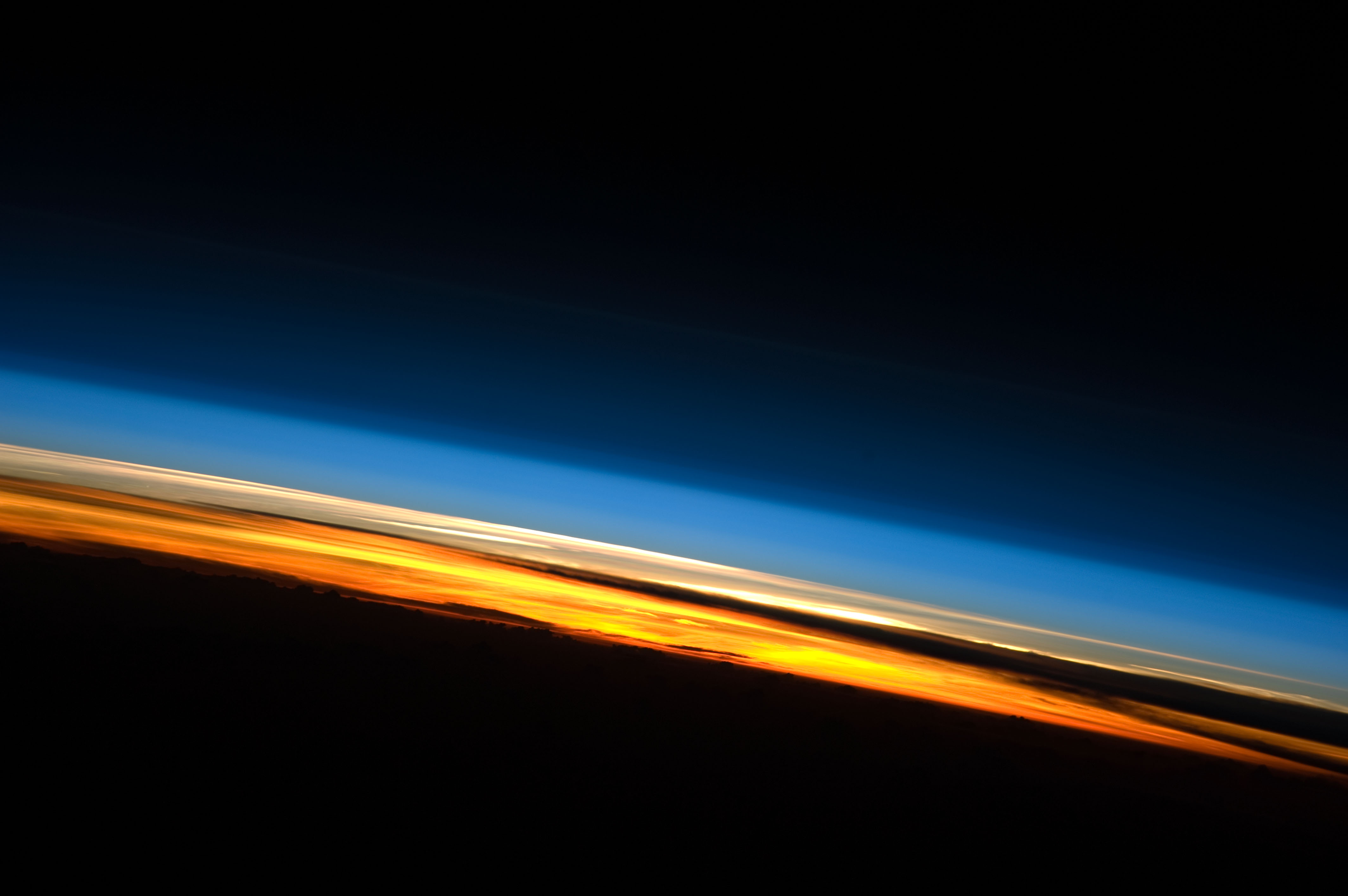
English: This spectacular image of sunset on the Indian Ocean was taken by astronauts aboard the International Space Station (ISS). The image presents an edge-on, or limb view, of the Earth’s atmosphere as seen from orbit. The Earth’s curvature is visible along the horizon line, or limb, that extends across the image from centre left to lower right. Above the darkened surface of the Earth, a brilliant sequence of colours roughly denotes several layers of the atmosphere.
Deep oranges and yellows appear in the troposphere, which extends from the Earth’s surface to 6–20 km high. This layer contains over 80 percent of the mass of the atmosphere and almost all of the water vapour, clouds, and precipitation. Several dark cloud layers are visible within this layer. Variations in the colours are due mainly to varying concentrations of either clouds or aerosols (airborne particles or droplets). The pink to white region above the clouds appears to be the stratosphere; this atmospheric layer generally has little or no clouds and extends up to approximately 50 km above the Earth’s surface. Above the stratosphere, blue layers mark the upper atmosphere (including the mesosphere, thermosphere, ionosphere, and exosphere) as it gradually fades into the blackness of outer space. The ISS was located over the southern Indian Ocean when this picture was taken, with the astronaut observer looking towards the west. Astronauts aboard the ISS see 16 sunrises and sunsets per day due to their high orbital velocity (greater than 28,000 km per hour). The multiple chances for photography are fortunate, as at that speed each sunrise or sunset event only lasts a few seconds! Image acquired with a Nikon D3 digital camera, and is provided by the ISS Crew Earth Observations experiment and Image Science & Analysis Laboratory, Johnson Space Center.
Español: esta imagen espectacular de un atardecer sobre el Océano Índico fue tomada por astronautas a bordo de la Estación Espacial Internacional (EEI). La imagen presenta una vista del borde de la tierra, vista desde su orbita. La curvatura de la tierra es visible a lo largo de la línea del horizonte, que se extiende a través de la imagen desde el centro del lado izquierdo, hasta la esquina inferior derecha. Sobre la oscurecida superficie de la Tierra, una brillante secuencia de colores denota a grandes razgos varias capas de la atmósfera.
Los naranjas profundos y amarillos aparecen en la tropósfera, que se extiende desde la superficie terrestre a 6-20 km de alto. Esta capa contiene más del 80% de la masa de la atmósfera y casi todo el vapor de agua, las nubes y las precipitaciones. Varias capas oscuras de nubes son visibles en esta capa. Las variaciones de color son debidas principalmente a concentraciones variables de nubes o aerosoles (particulas o gotas suspendidas en el aire). La región rosa a blanca sobre las nubes parece ser la estratósfera; esta capa atmosférica generalmente no contiene prácticamente nubes, y se extiende hasta aproximadamente 50km sobre la superficie terrestre. Sobre la estratósfera, capas azules marcan la atmósfera superior (incluyendo la mesósfera, termósfera, ionósfera y exósfera) y gradualmente se desvanece a la profunda oscuridad del espacio exterior. La EEI estaba localizada sobre el Océano Índico cuando esta foto fue tomada, con el astronauta observando hacia el oeste. Los astronautas a bordo de la EEI ven 16 amaneceres y atardeceres por día debido a su gran velocidad orbital (mayor a 28,000 km por hora). Las múltiples oportunidades para la fotografía son verdaderamente escasas, ya que a esa velocidad cada amanecer o atardecer solo dura unos segundos! Imagen obtenida con una cámara digital Nikon D3, provista para el experimento de Observaciones de la Tierra por la tripulación de la EEI y el Laboratorio de Imágenes y Análisis del Centro Espacial Johnson.
മലയാളം: അന്താരാഷ്ട്ര ബഹിരാകാശ നിലയത്തിലെ (ISS) ബഹിരാകാശയാത്രികർ ഇന്ത്യൻ മഹാസമുദ്രത്തിനു മുകളിൽ നിന്നാണ് ഈ സവിശേഷ ചിത്രം എടുത്തത്. ഭൗമാന്തരീക്ഷം ഭ്രമണപഥത്തിൽ നിന്ന് എപ്രകാരമാണ് ദൃശ്യമാവുക എന്ന് ഈ ചിത്രത്തിലുണ്ട്. ഇടതു മദ്ധ്യത്തിൽ നിന്ന് താഴെ വലതുവരെയുള്ള ചാപമായി ഭൂമിയും കാണം. കറുത്ത നിറത്തിലുള്ള ഭൗമോപരിതലത്തിനു മുകളിലായി, അന്തരീക്ഷത്തിന്റെ വിവിധ മേഖലകളെ കുറിക്കുന്ന തലങ്ങൾ വ്യത്യസ്തനിറങ്ങളിൽ ദൃശ്യമായിരിക്കുന്നതു കാണാം.
ട്രോപോസ്ഫിയർ കടുത്ത ഓറഞ്ചും മഞ്ഞയും നിറത്തിൽ കാണാം, ഭൗമോപരിതലത്തിൽ നിന്ന് 6–20 കി.മീ. ഉയരമാണിത്. അന്തരീക്ഷത്തിന്റെ ആകെ പിണ്ഡത്തിന്റെ 80 ശതമാനവും മിക്കവാറും മുഴുവൻ നീരാവിയും, മേഘം|മേഘങ്ങളും, ആർദ്രതയും ഇവിടെയാണുള്ളത്. നിരവധി ഇരുണ്ട മേഘതലങ്ങൾ ഈ മേഖലയിൽ കാണാം. നിറത്തിലെ വ്യത്യാസം മിക്കവാറും പൊടി-ജല-പടലങ്ങളുടെ സാന്ദ്രതാവ്യത്യാസം കൊണ്ടുണ്ടായിരിക്കുന്നതാണ്. മേഘങ്ങൾക്കുപരിയായി പിങ്ക് മുതൽ വെള്ള വരെയുള്ള ഭാഗങ്ങൾ സ്ട്രാറ്റോസ്ഫിയർ ആണ്; ഭൗമോപരിതലത്തിനു 50 കി.മീ. വരെ ഉയരത്തിലുണ്ടാകാറുള്ള ഈ ഭാഗത്ത് മേഘങ്ങൾ അതിവിരളമായേ ഉണ്ടാകൂ. സ്ട്രാറ്റോസ്ഫിയറിനു മുകളിലായി, നീല തലങ്ങൾ ബാഹ്യാന്തരീക്ഷത്തെ കാണിക്കുന്നു (മെസോസ്ഫിയർ, തെർമോസ്ഫിയർ, അയണോസ്ഫിയർ, എക്സോസ്ഫിയർ എന്നിവയുൾപ്പെടെ). അവ പിന്നീട് ക്രമേണ ബഹിരാകാശത്തിന്റെ ഇരുട്ടിൽ ചേരുന്നു. ഈ ചിത്രം എടുത്തപ്പോൾ അന്താരാഷ്ട്ര ബഹിരാകാശ നിലയം, പടിഞ്ഞാറോട്ട് ദർശിച്ച് നിൽക്കുന്ന സഞ്ചാരികളുമായി ദക്ഷിണ ഇന്ത്യൻ മഹാസമുദ്രത്തിനു മുകളിലായിരുന്നു ഉള്ളത്. കേന്ദ്രത്തിലെ സഞ്ചാരികൾ അവരുടെ ഉയർന്ന ഭമണപഥ പ്രവേഗം മൂലം (മണിക്കൂറിൽ 28,000 കി.മീ.), ദിവസേന 16 ഉദയാസ്തമയങ്ങൾ കാണുന്നു. എങ്കിലും ഓരോ ഉദയവും അസ്തമയവും ഏതാനം സെക്കന്റുകൾ മാത്രമേ നീണ്ടുനിൽക്കുകയുള്ളു എന്നതിനാൽ ഒരു ദൃശ്യം തന്നെ വീണ്ടും ചിത്രീകരിക്കാനുള്ള അവസരം അതിവിരളമാണ്. ഭൗമനിരീക്ഷണത്തിനായി ജോൺസൺ ബഹിരാകാശ കേന്ദ്രത്തിൽ നിന്നു നൽകിയിട്ടുള്ള നികോൺ ഡി3 ഡിജിറ്റൽ കാമറ ഉപയോഗിച്ചാണ് ചിത്രം എടുത്തിരിക്കുന്നത്. |
| Date | |
| Source | NASA Earth Observatory |
| Auteur | ISS Expedition 23 crew |
| Lieu de la prise de vue | | Voir cet endroit et d’autres images sur : OpenStreetMap |
|---|
Cette image ou vidéo a été cataloguée par le Johnson Space Center de la National Aeronautics and Space Administration (NASA) des États-Unis sous Photo ID : ISS023-E-57948.Ce bandeau n’indique rien sur le statut de l’œuvre au regard du droit d'auteur. Un bandeau de droit d’auteur est requis. Voir Commons:À propos des licences pour plus d’informations. Autres langues :
|
Conditions d’utilisation
| Ce fichier provient de la NASA. Sauf exception, les documents créés par la NASA ne sont pas soumis à copyright. Pour plus d'informations, voir la politique de copyright de la NASA. | ||
 |
Attention :
|
| Annotations | Cette image est annotée : Voir les annotations sur Wikimedia Commons |
Historique du fichier
Cliquer sur une date et heure pour voir le fichier tel qu'il était à ce moment-là.
| Date et heure | Vignette | Dimensions | Utilisateur | Commentaire | |
|---|---|---|---|---|---|
| actuel | 14 juin 2010 à 12:07 | | 4 256 × 2 829 (391 kio) | Originalwana | {{Information |Description={{en|1=This spectacular image of sunset on the Indian Ocean was taken by astronauts aboard the International Space Station (ISS). The image presents an edge-on, or limb view, of the Earth’s atmosphere as seen from [[or |
Utilisation du fichier
Les 2 pages suivantes utilisent ce fichier :
Usage global du fichier
Les autres wikis suivants utilisent ce fichier :
- Utilisation sur ast.wikipedia.org
- Utilisation sur br.wikipedia.org
- Utilisation sur ca.wikipedia.org
- Utilisation sur en.wikipedia.org
- Utilisation sur en.wikiquote.org
- Utilisation sur en.wikiversity.org
- Utilisation sur es.wikipedia.org
- Utilisation sur eu.wikipedia.org
- Utilisation sur fa.wikipedia.org
- Utilisation sur fi.wikipedia.org
- Utilisation sur ga.wikipedia.org
- Utilisation sur io.wiktionary.org
- Utilisation sur is.wikipedia.org
- Utilisation sur ja.wikipedia.org
- Utilisation sur kk.wikipedia.org
- Utilisation sur lb.wikipedia.org
- Utilisation sur lt.wikipedia.org
- Utilisation sur ml.wikipedia.org
- Utilisation sur nl.wikipedia.org
- Utilisation sur nl.wiktionary.org
- Utilisation sur no.wikipedia.org
- Utilisation sur ps.wikipedia.org
- Utilisation sur ru.wikipedia.org
- Utilisation sur sa.wikipedia.org
- Utilisation sur sco.wikipedia.org
- Utilisation sur uk.wikipedia.org
- Utilisation sur uz.wikipedia.org
- Utilisation sur uz.wiktionary.org
- Utilisation sur www.wikidata.org