Fichier:Super Pit Mine, Kalgoorlie, Western Australia.jpg

Taille de cet aperçu : 600 × 600 pixels. Autres résolutions : 240 × 240 pixels | 480 × 480 pixels | 768 × 768 pixels | 1 024 × 1 024 pixels | 2 048 × 2 048 pixels | 3 000 × 3 000 pixels.
Fichier d’origine (3 000 × 3 000 pixels, taille du fichier : 3,46 Mio, type MIME : image/jpeg)
Ce fichier et sa description proviennent de Wikimedia Commons.
Description
| Description |
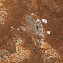
English: The pit that gives the mine its name appears in the centre of the image, and some of the steep pit’s walls appear in shadow while others are illuminated by the Sun. Related mining operations form a rough semicircle on the eastern side of the pit; a cluster of buildings east-north-east of the pit is Fimiston Mill, where ore is processed. Waste dumps and grey-white tailings ponds sprawl over the arid landscape. Tailings are the rocks and chemicals left over after the gold is extracted. Because the chemicals used to separate gold from rock are often caustic, tailings usually pose hazards to human and/or environmental health and must be treated carefully. The metropolitan area of Kalgoorlie, marked by street grids and manicured green spaces, extends almost to the mine’s central pit. An airport, marked by a long runway, appears along the city’s southern margin. Founded during a late-nineteenth-century gold rush, Kalgoorlie, like the neighboring mine, occurs near an area nicknamed the “Golden Mile,” which is considered especially rich in gold deposits. As the beige and reddish colors in the image indicate, vegetation in the area is sparse. |
| Date | |
| Source | NASA Earth Observatory |
| Auteur | Jesse Allen |
Image captured by the Advanced Land Imager (ALI) on NASA’s Earth Observing-1 (EO-1) satellite. Data provided courtesy of the NASA EO-1 team.
Conditions d’utilisation
| Ce fichier provient de la NASA. Sauf exception, les documents créés par la NASA ne sont pas soumis à copyright. Pour plus d'informations, voir la politique de copyright de la NASA. | ||
 |
Attention :
|
| Annotations | Cette image est annotée : Voir les annotations sur Wikimedia Commons |
Historique du fichier
Cliquer sur une date et heure pour voir le fichier tel qu'il était à ce moment-là.
| Date et heure | Vignette | Dimensions | Utilisateur | Commentaire | |
|---|---|---|---|---|---|
| actuel | 22 février 2010 à 14:11 | | 3 000 × 3 000 (3,46 Mio) | Originalwana | {{Information |Description={{en|1=The pit that gives the mine its name appears in the centre of the image, and some of the steep pit’s walls appear in shadow while others are illuminated by the Sun. Related mining operations form a rough semicir |
Utilisation du fichier
La page suivante utilise ce fichier :
Usage global du fichier
Les autres wikis suivants utilisent ce fichier :
- Utilisation sur ckb.wikipedia.org
- Utilisation sur cs.wikipedia.org
- Utilisation sur en.wikipedia.org
- Utilisation sur fa.wikipedia.org
- Utilisation sur nl.wikipedia.org
- Utilisation sur www.wikidata.org