Fichier:Trafalgar 1200hr.gif
Taille de cet aperçu : 635 × 600 pixels. Autres résolutions : 254 × 240 pixels | 508 × 480 pixels | 900 × 850 pixels.
Fichier d’origine (900 × 850 pixels, taille du fichier : 30 kio, type MIME : image/gif)
Ce fichier et sa description proviennent de Wikimedia Commons.

|
Ce fichier a été remplacé par File:Trafalgar 1200hr.svg. Il est recommandé d’utiliser l’autre fichier. La suppression des fichiers remplacés requiert un accord. Raison: «The new file is SVG, and has less spelling mistakes»
|

|
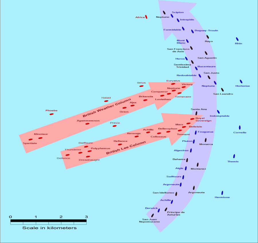
- Description: This map of the Battle of Trafalgar shows the approximate position of the two fleets at 1200 hours during the battle as the Royal Sovereign was breaking into the Franco-Spanish line. North is to the top, and Cape Trafalgar is 10 miles to the northeast.
- Size: 900 × 850 pixels.
- Source: This drawing is based on an illustration in issue number 84 of the Strategy & Tactics magazine The map was made by RJHall using the Campaign Cartographer drawing program, and the image was reduced in size 50% in Paint Shop Pro. Ship icons are not to scale.
Ce fichier est disponible selon les termes de la licence Creative Commons Attribution – Partage dans les Mêmes Conditions 2.5 Générique
- Vous êtes libre :
- de partager – de copier, distribuer et transmettre cette œuvre
- d’adapter – de modifier cette œuvre
- Sous les conditions suivantes :
- paternité – Vous devez donner les informations appropriées concernant l'auteur, fournir un lien vers la licence et indiquer si des modifications ont été faites. Vous pouvez faire cela par tout moyen raisonnable, mais en aucune façon suggérant que l’auteur vous soutient ou approuve l’utilisation que vous en faites.
- partage à l’identique – Si vous modifiez, transformez, ou vous basez sur cette œuvre, vous devez distribuer votre contribution sous la même licence ou une licence compatible avec celle de l’original.
Historique du fichier
Cliquer sur une date et heure pour voir le fichier tel qu'il était à ce moment-là.
| Date et heure | Vignette | Dimensions | Utilisateur | Commentaire | |
|---|---|---|---|---|---|
| actuel | 28 juillet 2005 à 16:30 | | 900 × 850 (30 kio) | RJHall | Battle of Trafalgar situation at 1200hr, 21 October 1805. |
Utilisation du fichier
La page suivante utilise ce fichier :
Usage global du fichier
Les autres wikis suivants utilisent ce fichier :
- Utilisation sur ja.wikipedia.org