Fichier:Twin Cities Metro Area (13 County).png

Taille de cet aperçu : 775 × 600 pixels. Autres résolutions : 310 × 240 pixels | 620 × 480 pixels | 992 × 768 pixels | 1 280 × 991 pixels | 1 500 × 1 161 pixels.
Fichier d’origine (1 500 × 1 161 pixels, taille du fichier : 866 kio, type MIME : image/png)
Ce fichier et sa description proviennent de Wikimedia Commons.
.png?uselang=fr)
Description
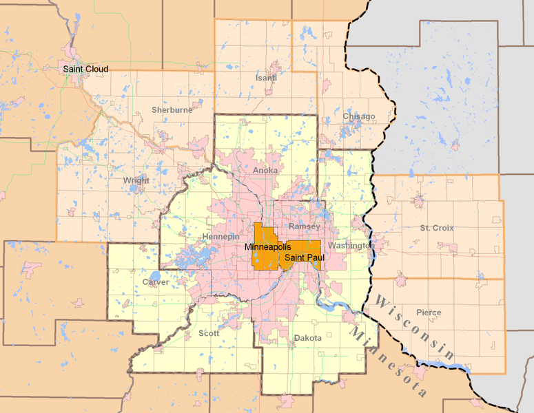
| Description | Minneapolis-Saint Paul (Twin Cities) highlighting both the 7-county Urban Area (traditional) and the revised 13-county Metropolitan Statistical Area from the 2000 Census. Today, the term Twin Cities typically refers to the metropolitan area. The pink areas represent urbanized areas as defined by the Metropolitan Council (urbanized meaning developed with sewer access and includes suburbia and small towns). The red and green lines are highways while the grid-like lines within the counties are township boundaries and mostly rural. Suburban cities are also defined within the pink area however they are not as apparent since their borders so regularly match up with existing highways and natural features. |
| Date | |
| Source | Own work by uploader using publicly and freely available cartographic data by state and private agencies. Raster by MapInfo, purchased for personal use and distributed for no monetary gain. |
| Auteur | Davumaya |
| Autorisation (Réutilisation de ce fichier) |
Agencies providing this data and myself make no assertion that this data is an accurate representation or legally defined. It is provided as a fair representation and should not be used for legal purposes. |
Conditions d’utilisation
Moi, en tant que détenteur des droits d’auteur sur cette œuvre, je la publie sous la licence suivante :
Ce fichier est disponible selon les termes de la licence Creative Commons Attribution – Partage dans les Mêmes Conditions 3.0 (non transposée).
- Vous êtes libre :
- de partager – de copier, distribuer et transmettre cette œuvre
- d’adapter – de modifier cette œuvre
- Sous les conditions suivantes :
- paternité – Vous devez donner les informations appropriées concernant l'auteur, fournir un lien vers la licence et indiquer si des modifications ont été faites. Vous pouvez faire cela par tout moyen raisonnable, mais en aucune façon suggérant que l’auteur vous soutient ou approuve l’utilisation que vous en faites.
- partage à l’identique – Si vous modifiez, transformez, ou vous basez sur cette œuvre, vous devez distribuer votre contribution sous la même licence ou une licence compatible avec celle de l’original.
Historique du fichier
Cliquer sur une date et heure pour voir le fichier tel qu'il était à ce moment-là.
| Date et heure | Vignette | Dimensions | Utilisateur | Commentaire | |
|---|---|---|---|---|---|
| actuel | 12 août 2008 à 23:27 | | 1 500 × 1 161 (866 kio) | Davumaya | {{Information |Description= |Source= |Date= |Author= |Permission= |other_versions= }} <!--{{ImageUpload|basic}}--> |
| 12 août 2008 à 23:22 |  | 2 000 × 1 545 (238 kio) | Davumaya | {{Information |Description=Minneapolis-Saint Paul (Twin Cities) highlighting both the 7-county Urban Area (traditional) and the revised 13-county Metropolitan Statistical Area from the 2000 Census. |Source=Own work by uploader using publicly and freely a |
Utilisation du fichier
Aucune page n’utilise ce fichier.
Usage global du fichier
Les autres wikis suivants utilisent ce fichier :
- Utilisation sur de.wikipedia.org
- Utilisation sur en.wikipedia.org
- Utilisation sur fi.wikipedia.org
- Utilisation sur ja.wikipedia.org
- Utilisation sur nl.wikipedia.org
- Utilisation sur pl.wikipedia.org
- Utilisation sur ro.wikipedia.org
- Utilisation sur simple.wikipedia.org
- Utilisation sur sv.wikipedia.org
- Utilisation sur vi.wikipedia.org
.png)