Fichier:WVStatehoodVote.png
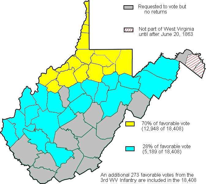
WVStatehoodVote.png (672 × 600 pixels, taille du fichier : 115 kio, type MIME : image/png)
Historique du fichier
Cliquer sur une date et heure pour voir le fichier tel qu'il était à ce moment-là.
| Date et heure | Vignette | Dimensions | Utilisateur | Commentaire | |
|---|---|---|---|---|---|
| actuel | 4 février 2011 à 18:19 |  | 672 × 600 (115 kio) | Maproom | Repaired broken characters "a", "8". Reduced fringes from floodfill. |
| 27 septembre 2009 à 02:11 |  | 672 × 600 (122 kio) | Dubyavee | Corrected some errors in numbers, noted small soldier vote | |
| 27 juillet 2009 à 00:29 |  | 672 × 600 (125 kio) | Dubyavee | changed Raleigh county from 'gray' to 'blue' to correct error in original. | |
| 27 juillet 2009 à 00:11 |  | 672 × 600 (125 kio) | Dubyavee | {{Information |Description={{en|1=Map created based on the voting results of statehood referendum on Oct. 24, 1861 in West Virginia as compiled by Richard O. Curry in "A House Divided", pgs. 141-152.}} |Source=My creation from data in R. Curry's "A House |
Utilisation du fichier
La page suivante utilise ce fichier :
Usage global du fichier
Les autres wikis suivants utilisent ce fichier :
- Utilisation sur fy.wikipedia.org
- Utilisation sur it.wikipedia.org
- Utilisation sur ja.wikipedia.org
- Utilisation sur ko.wikipedia.org
