Fichier:Weddell-Island-Map.png

Taille de cet aperçu : 560 × 600 pixels. Autres résolutions : 224 × 240 pixels | 588 × 630 pixels.
Fichier d’origine (588 × 630 pixels, taille du fichier : 245 kio, type MIME : image/png)
Ce fichier et sa description proviennent de Wikimedia Commons.
Description
| Description |
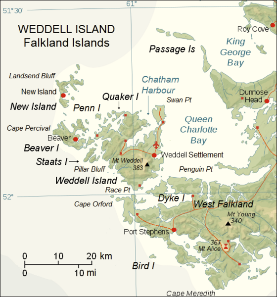
English: Upgraded topographic map of Weddell Island area, Falkland Islands |
| Date | |
| Source | File:Falkland Islands topographic map-en.svg |
| Auteur | Eric Gaba (Sting), fragment revised by Apcbg |
| Lieu de la prise de vue | | Voir cet endroit et d’autres images sur : OpenStreetMap |
|---|
Conditions d’utilisation
Ce fichier est disponible selon les termes de la licence Creative Commons Attribution – Partage dans les Mêmes Conditions 3.0 (non transposée).
- Vous êtes libre :
- de partager – de copier, distribuer et transmettre cette œuvre
- d’adapter – de modifier cette œuvre
- Sous les conditions suivantes :
- paternité – Vous devez donner les informations appropriées concernant l'auteur, fournir un lien vers la licence et indiquer si des modifications ont été faites. Vous pouvez faire cela par tout moyen raisonnable, mais en aucune façon suggérant que l’auteur vous soutient ou approuve l’utilisation que vous en faites.
- partage à l’identique – Si vous modifiez, transformez, ou vous basez sur cette œuvre, vous devez distribuer votre contribution sous la même licence ou une licence compatible avec celle de l’original.
Historique du fichier
Cliquer sur une date et heure pour voir le fichier tel qu'il était à ce moment-là.
| Date et heure | Vignette | Dimensions | Utilisateur | Commentaire | |
|---|---|---|---|---|---|
| actuel | 23 mai 2018 à 09:45 | | 588 × 630 (245 kio) | Apcbg | details |
| 7 mai 2018 à 13:53 |  | 588 × 630 (190 kio) | Apcbg | detail | |
| 27 avril 2018 à 12:15 |  | 588 × 630 (244 kio) | Apcbg | detail | |
| 27 avril 2018 à 09:15 |  | 588 × 630 (244 kio) | Apcbg | detail | |
| 20 avril 2018 à 14:21 |  | 588 × 630 (244 kio) | Apcbg | detail | |
| 20 avril 2018 à 09:50 |  | 588 × 630 (244 kio) | Apcbg | details | |
| 20 avril 2018 à 08:44 |  | 588 × 630 (244 kio) | Apcbg | detail | |
| 18 avril 2018 à 20:21 |  | 588 × 630 (190 kio) | Apcbg | colour | |
| 19 mars 2018 à 11:46 |  | 588 × 630 (243 kio) | Apcbg | detail | |
| 19 mars 2018 à 10:39 |  | 588 × 630 (242 kio) | Apcbg | details |
Utilisation du fichier
Les 4 pages suivantes utilisent ce fichier :
Usage global du fichier
Les autres wikis suivants utilisent ce fichier :
- Utilisation sur de.wikipedia.org
- Utilisation sur en.wikipedia.org
- Weddell Island
- Horse Block
- Race Point
- Swan Point, Weddell Island
- Weddell Settlement
- Mount Weddell
- Pillar Bluff
- Chatham Harbour, Weddell Island
- French Harbour
- Weddell Point, Weddell Island
- Gull Harbour
- Quaker Harbour
- Loop Head, Weddell Island
- New Year Cove
- Smylie Channel
- Hotham Heights
- Pitt Heights
- Mount Alice (Falkland Islands)
- Circum Peak
- Utilisation sur www.wikidata.org