Fichier:Wutach w-o-GeoSchnitt.jpg
Taille de cet aperçu : 799 × 225 pixels. Autres résolutions : 320 × 90 pixels | 640 × 180 pixels | 1 800 × 507 pixels.
Fichier d’origine (1 800 × 507 pixels, taille du fichier : 425 kio, type MIME : image/jpeg)
Ce fichier et sa description proviennent de Wikimedia Commons.
| Description |
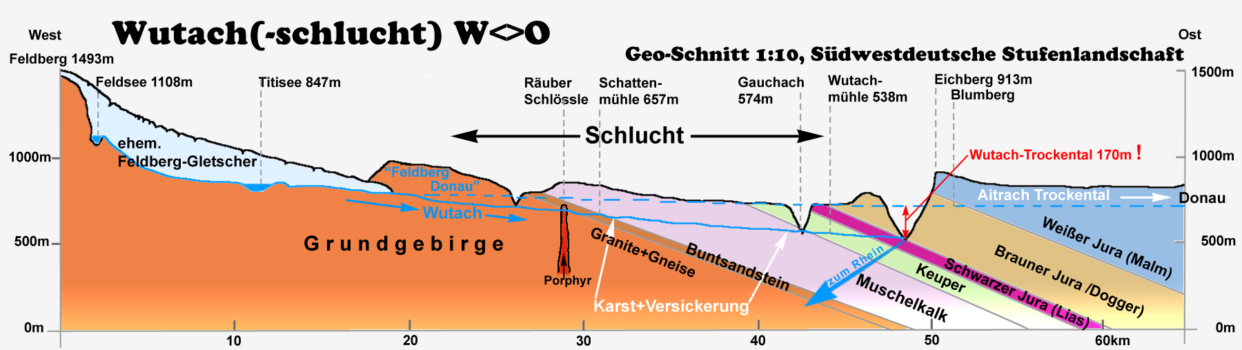
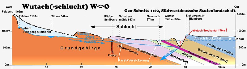
English: Schematic overview of the outcrops of all geological strata in south west Germany. The enormous holocene erosion of the Wutach River is a most prominent example for geology in situ.
Deutsch: Geologisches Profil (west-ost) des Südwestdeutschen Schichtstufenlandes endlang der oberen Wutach mit Kennzeichnung des Verlaufs der so genannten „Feldbergdonau". Hohe Reliefenergie im Holozän schuf zahlreiche Aufschlüsse der Gesteinsschichten. Erstklassiges Anschaungsmaterial für die Geologie: Die Wutachschlucht schneidet auf nur 20km alle geologischen Schichten Südwestdeutschlands an und macht sie sichtbar. |
| Date | |
| Source | image by author; based on material from „Regierungspräsidium Freiburg, Ref. 56, Naturschutz + Landschaftspflege" |
| Auteur | Ustill |
Ce fichier est disponible selon les termes de la licence Creative Commons Attribution – Partage dans les Mêmes Conditions 2.0 Allemagne.
- Vous êtes libre :
- de partager – de copier, distribuer et transmettre cette œuvre
- d’adapter – de modifier cette œuvre
- Sous les conditions suivantes :
- paternité – Vous devez donner les informations appropriées concernant l'auteur, fournir un lien vers la licence et indiquer si des modifications ont été faites. Vous pouvez faire cela par tout moyen raisonnable, mais en aucune façon suggérant que l’auteur vous soutient ou approuve l’utilisation que vous en faites.
- partage à l’identique – Si vous modifiez, transformez, ou vous basez sur cette œuvre, vous devez distribuer votre contribution sous la même licence ou une licence compatible avec celle de l’original.

Historique du fichier
Cliquer sur une date et heure pour voir le fichier tel qu'il était à ce moment-là.
| Date et heure | Vignette | Dimensions | Utilisateur | Commentaire | |
|---|---|---|---|---|---|
| actuel | 26 mars 2016 à 18:16 | 1 800 × 507 (425 kio) | Ustill | Schreibfehler korrigiert | |
| 17 mai 2008 à 02:00 | 1 800 × 507 (422 kio) | Ustill | {{Information| |Description= {{en| Schematic overview of the outcrops of all geological strata in south west Germany. The enormous holocene erosion of the Wutach River is a most prominent example for geology in situ.} |
Utilisation du fichier
La page suivante utilise ce fichier :
Usage global du fichier
Les autres wikis suivants utilisent ce fichier :
- Utilisation sur als.wikipedia.org
- Utilisation sur de.wikipedia.org
- Utilisation sur en.wikipedia.org