Fichier:Canada 1896 Federal Election.svg

Taille de cet aperçu PNG pour ce fichier SVG : 706 × 599 pixels. Autres résolutions : 283 × 240 pixels | 566 × 480 pixels | 905 × 768 pixels | 1 207 × 1 024 pixels | 2 413 × 2 048 pixels | 1 084 × 920 pixels.
Fichier d’origine (Fichier SVG, nominalement de 1 084 × 920 pixels, taille : 399 kio)
Ce fichier et sa description proviennent de Wikimedia Commons.
Description
| Description |
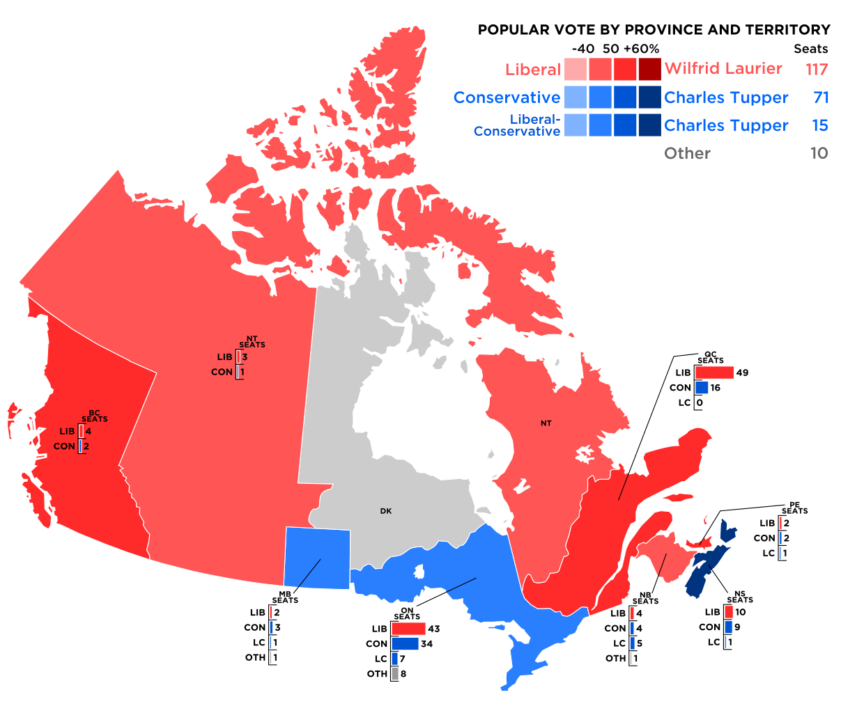
English: Result of the popular vote in the 1896 Canadian federal election.
Note:This map is still awaiting information regarding which islands belonged to District of Keewatin and the North-West Territories |
||
| Date | |||
| Source |
Created by Lokal_Profil.
|
||
| Auteur | Lokal_Profil | ||
| Autorisation (Réutilisation de ce fichier) |
Ce fichier est disponible selon les termes de la licence Creative Commons Attribution – Partage dans les Mêmes Conditions 2.5 Générique Attribution: Lokal_Profil
|
||
| Autres versions |
|
Historique du fichier
Cliquer sur une date et heure pour voir le fichier tel qu'il était à ce moment-là.
| Date et heure | Vignette | Dimensions | Utilisateur | Commentaire | |
|---|---|---|---|---|---|
| actuel | 20 septembre 2009 à 07:06 | | 1 084 × 920 (399 kio) | Lokal Profil | Converted text to paths. Use the previous revision for derivative works and corrections |
| 20 septembre 2009 à 07:04 |  | 1 084 × 920 (218 kio) | Lokal Profil | Extracting Lib-Con from Others | |
| 20 septembre 2009 à 02:41 |  | 1 084 × 920 (363 kio) | Lokal Profil | Converted text to paths. Use the previous revision for derivative works and corrections | |
| 20 septembre 2009 à 02:40 |  | 1 084 × 920 (219 kio) | Lokal Profil | Minor adjustment | |
| 20 septembre 2009 à 02:08 |  | 1 084 × 920 (363 kio) | Lokal Profil | Converted text to paths. Use the previous revision for derivative works and corrections. The fonts used were Gotham Medium (titles and total seats) and Gotham Bold (party abbreviation and seats) | |
| 20 septembre 2009 à 02:07 |  | 1 084 × 920 (219 kio) | Lokal Profil | == {{int:filedesc}} == {{Information |Description={{en|1=Result of the popular vote in the 1896 Canadian federal election.}} Note:This map is still awaiting information regarding which islands belonged to District of Keewatin and the North-West Territori |
Utilisation du fichier
Les 5 pages suivantes utilisent ce fichier :
Usage global du fichier
Les autres wikis suivants utilisent ce fichier :
- Utilisation sur de.wikipedia.org
- Utilisation sur en.wikipedia.org
- Utilisation sur es.wikipedia.org
- Utilisation sur he.wikipedia.org