Fichier:High Speed Railroad Map of the United States 2013.svg

Taille de cet aperçu PNG pour ce fichier SVG : 800 × 489 pixels. Autres résolutions : 320 × 196 pixels | 640 × 391 pixels | 1 024 × 626 pixels | 1 280 × 782 pixels | 2 560 × 1 565 pixels | 975 × 596 pixels.
Fichier d’origine (Fichier SVG, nominalement de 975 × 596 pixels, taille : 232 kio)
Ce fichier et sa description proviennent de Wikimedia Commons.
Description

|
Ce fichier peut être mis à jour pour contenir de nouvelles informations. Si vous voulez utiliser une version spécifique de ce fichier sans que les mises à jour ne s’affichent, merci d’importer la version en question dans un fichier séparé. |
| Description |
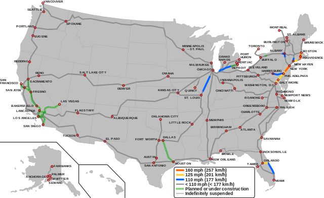
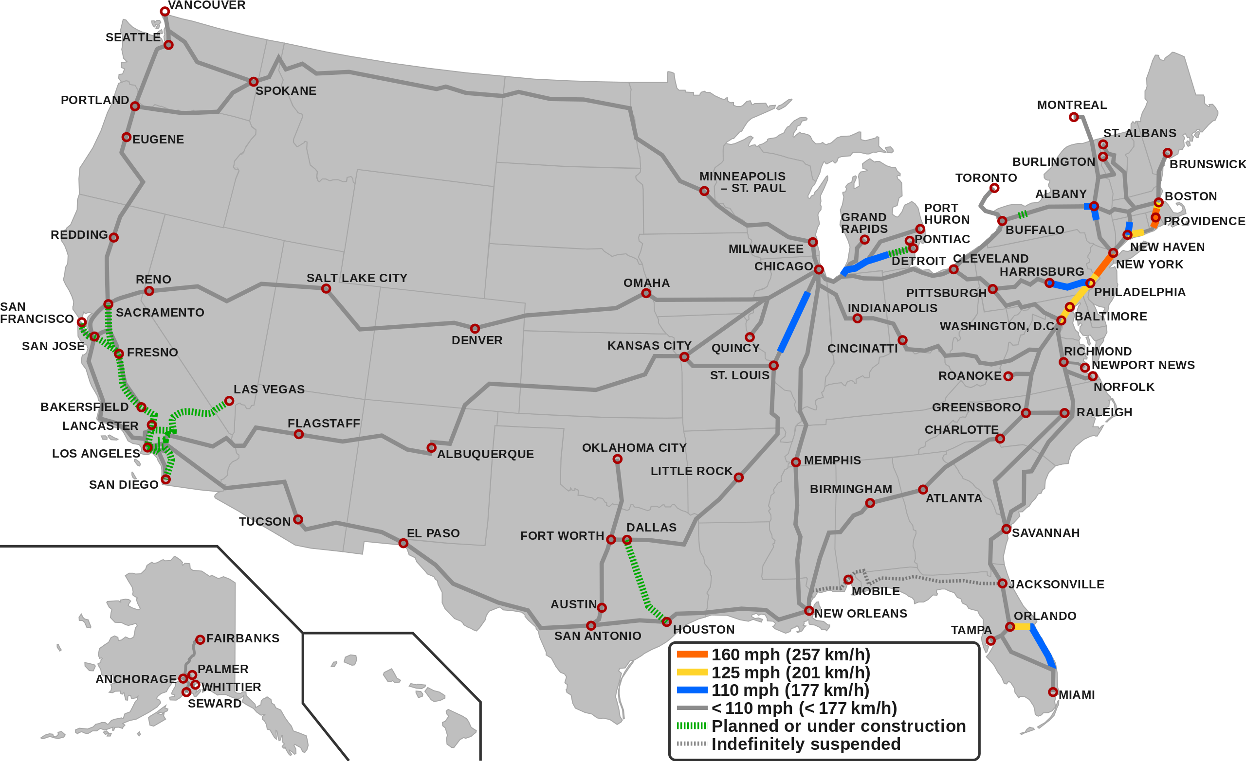
English (en): Map showing the high-speed rail network of the United States.1
160 mph (257 km/h) 125 mph (201 km/h) 110 mph (177 km/h) < 110 mph (< 177 Km/h) Planned/Under construction Indefinitely suspended
1 The map depicts the actual operational high-speed instead of the designed one which may be higher.
|
| Date | |
| Source |
|
| Auteur |
|
Conditions d’utilisation
Ce fichier est disponible selon les termes de la licence Creative Commons Attribution – Partage dans les Mêmes Conditions 3.0 (non transposée).
- Vous êtes libre :
- de partager – de copier, distribuer et transmettre cette œuvre
- d’adapter – de modifier cette œuvre
- Sous les conditions suivantes :
- paternité – Vous devez donner les informations appropriées concernant l'auteur, fournir un lien vers la licence et indiquer si des modifications ont été faites. Vous pouvez faire cela par tout moyen raisonnable, mais en aucune façon suggérant que l’auteur vous soutient ou approuve l’utilisation que vous en faites.
- partage à l’identique – Si vous modifiez, transformez, ou vous basez sur cette œuvre, vous devez distribuer votre contribution sous la même licence ou une licence compatible avec celle de l’original.
Historique du fichier
Cliquer sur une date et heure pour voir le fichier tel qu'il était à ce moment-là.
| Date et heure | Vignette | Dimensions | Utilisateur | Commentaire | |
|---|---|---|---|---|---|
| actuel | 6 décembre 2023 à 07:55 | | 975 × 596 (232 kio) | QuincyMorgan | Reverted to version as of 15:45, 2 December 2023 (UTC). State abbreviations overlap other stuff and make the map very hard to read |
| 3 décembre 2023 à 07:24 |  | 975 × 596 (258 kio) | G13178m | Added state labels and changed text fonts to Arial. | |
| 2 décembre 2023 à 17:45 |  | 975 × 596 (232 kio) | Einsof | Adjust color contrast and line widths so that readers can actually see what is and is not HSR (the previous yellow was essentially invisible). Adjust city labels to try to make them readable without 500% zoom. Convert some effectively infinite-curvature smooth nodes into corner nodes so that they actually render (e.g.,at the Montreal terminus). Remove needless "Legend" text (if readers can't tell it's a legend, we've failed at making an understandable map). | |
| 23 septembre 2023 à 16:18 |  | 940 × 598 (762 kio) | QuincyMorgan | Add HSR operation of Brightline, Michigan Line, and Lincoln Service. Add Ethan Allen Express to Burlington. Adjust some city labels. Make suspended service less prominent. Remove SMART and Dubuque line since other regional rail and proposed conventional speed lines aren't shown. | |
| 26 janvier 2022 à 01:51 |  | 959 × 593 (643 kio) | Fluffy89502 | PA | |
| 18 novembre 2021 à 07:23 |  | 959 × 593 (643 kio) | Fluffy89502 | SMART | |
| 1 octobre 2021 à 20:48 |  | 959 × 593 (630 kio) | Fluffy89502 | San Diego correction | |
| 29 septembre 2021 à 04:11 |  | 959 × 593 (630 kio) | Fluffy89502 | No line over Tehachapi Pass, Phoenix has no rail service, marked Lancaster & Flagstaff | |
| 29 juillet 2021 à 00:11 |  | 959 × 593 (621 kio) | Iismitch55 | Added Roanoke VA branch, which is noted as major branch in sourced map | |
| 29 juillet 2021 à 00:09 |  | 959 × 593 (615 kio) | Iismitch55 | Reverted to version as of 19:20, 3 June 2021 (UTC) |
Utilisation du fichier
Les 5 pages suivantes utilisent ce fichier :
Usage global du fichier
Les autres wikis suivants utilisent ce fichier :
- Utilisation sur az.wikipedia.org
- Utilisation sur bg.wikipedia.org
- Utilisation sur ca.wikipedia.org
- Utilisation sur da.wikipedia.org
- Utilisation sur en.wikipedia.org
- Utilisation sur es.wikipedia.org
- Utilisation sur fa.wikipedia.org
- Utilisation sur hu.wikipedia.org
- Utilisation sur id.wikipedia.org
- Utilisation sur it.wikipedia.org
- Utilisation sur ja.wikipedia.org
- Utilisation sur pl.wikipedia.org
- Utilisation sur pt.wikipedia.org
- Utilisation sur test.wikipedia.org
- Utilisation sur tr.wikipedia.org
- Utilisation sur uk.wikipedia.org
- Utilisation sur zh.wikipedia.org