Fichier:Trafalgar 1200hr-fr.svg

Taille de cet aperçu PNG pour ce fichier SVG : 635 × 600 pixels. Autres résolutions : 254 × 240 pixels | 508 × 480 pixels | 813 × 768 pixels | 1 084 × 1 024 pixels | 2 168 × 2 048 pixels | 900 × 850 pixels.
Fichier d’origine (Fichier SVG, nominalement de 900 × 850 pixels, taille : 73 kio)
Ce fichier et sa description proviennent de Wikimedia Commons.
Description
| Description |
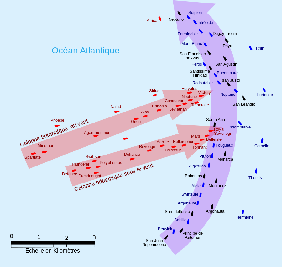
English: French version :This map of the Battle of Trafalgar shows the approximate position of the two fleets at 1200 hours during the battle as the Royal Sovereign was breaking into the Franco-Spanish line. North is to the top, and Cape Trafalgar is 10 miles to the northeast.
Français : Version française : Cette carte de la Bataille de Trafalgar montre les positions approximatives des deux flottes à 12 heures de la bataille lorsque la flotte royale aborde la ligne franco-espagnole. Le nord est en haut et le cap Trafalgar est à 10 miles au nord-est. |
| Date | |
| Source | own work made with Inkscape from Image:Trafalgar 1200hr.gif : This drawing is based on an illustration in issue number 84 of the Strategy & Tactics magazine The map was made by RJHall using the Campaign Cartographer drawing program, and the image was reduced in size 50% in Paint Shop Pro. Ship icons are not to scale. |
| Auteur | Pinpin |
| SVG information |
Conditions d’utilisation
Moi, en tant que détenteur des droits d’auteur sur cette œuvre, je la publie sous les licences suivantes :

|
Vous avez la permission de copier, distribuer et modifier ce document selon les termes de la GNU Free Documentation License version 1.2 ou toute version ultérieure publiée par la Free Software Foundation, sans sections inaltérables, sans texte de première page de couverture et sans texte de dernière page de couverture. Un exemplaire de la licence est inclus dans la section intitulée GNU Free Documentation License. |
Ce fichier est sous licence Creative Commons Attribution – Partage dans les Mêmes Conditions 3.0 (non transposée), 2.5 Générique, 2.0 Générique et 1.0 Générique.
- Vous êtes libre :
- de partager – de copier, distribuer et transmettre cette œuvre
- d’adapter – de modifier cette œuvre
- Sous les conditions suivantes :
- paternité – Vous devez donner les informations appropriées concernant l'auteur, fournir un lien vers la licence et indiquer si des modifications ont été faites. Vous pouvez faire cela par tout moyen raisonnable, mais en aucune façon suggérant que l’auteur vous soutient ou approuve l’utilisation que vous en faites.
- partage à l’identique – Si vous modifiez, transformez, ou vous basez sur cette œuvre, vous devez distribuer votre contribution sous la même licence ou une licence compatible avec celle de l’original.
Vous pouvez choisir l’une de ces licences.
Historique du fichier
Cliquer sur une date et heure pour voir le fichier tel qu'il était à ce moment-là.
| Date et heure | Vignette | Dimensions | Utilisateur | Commentaire | |
|---|---|---|---|---|---|
| actuel | 5 octobre 2007 à 08:35 | | 900 × 850 (73 kio) | Pinpin | |
| 3 octobre 2007 à 22:10 |  | 900 × 850 (73 kio) | Pinpin | forget one boat | |
| 3 octobre 2007 à 22:07 |  | 900 × 850 (72 kio) | Pinpin | == Description == {{Information |Description={{en|French version :This map of the '''Battle of Trafalgar''' shows the approximate position of the two fleets at 1200 hours during the battle as the Royal Sovereign was breaking into the Franco-Spanish li |
Utilisation du fichier
Les 11 pages suivantes utilisent ce fichier :
- Achille (1803)
- Bataille de Trafalgar
- England expects that every man will do his duty
- HMS Agamemnon (1781)
- HMS Bellerophon (1786)
- HMS Temeraire (1798)
- Michel Chesneau
- Olivier Jourdan de La Passardière
- Ordre de bataille de la bataille de Trafalgar
- Wikipédia:Atelier graphique/Images à améliorer/Archives/Septembre 2008
- Projet:Maritime/Bistro du port/Décembre 2013